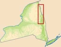
Driving through the villages and hamlets of New York's Lakes to Locks Passage, travelers are swept into a place of history. State parks and preserves offer hiking trails, lakeside beaches, and wildlife-spotting opportunities. Paralleling Lake Champlain and the Champlain Canal, the byway promises scenic views mixed with plenty of history.
Pre-colonial history is woven throughout the names of places and historic sites. The French explorer Samuel de Champlain named Lake Champlain in 1609. The struggle between nations and people occurred here between the Huron, Algonquin, and Iroquois. During the French and Indian War, the
Advertisement
French and British built settlements and fortifications all along the passage. Since then, many changes have moved through the Lakes to Locks Passage, but the natural beauty remains as a constant appeal to new explorers and visitors.
Explorers along the Lakes to Locks Passage travel the road by car, but those who know a little bit about the area bring a bicycle along, too. Lake Champlain Bikeways are known as some of the best cycling roads in the country.
Whether you travel by bicycle, on foot, or in the car, all the routes along the byway offer access to unique points of interest.
Cultural Qualities of Lakes to Locks Passage
Residents along the Lakes to Locks Passage look at their part of the country as a working land; the seasons harmonize with the agricultural activities that take place along the byway. From sugar in the winter to strawberries in the summer, the land along the passage is continually productive. This productivity began long ago with the Iroquois and Abenaki, who were able to develop strategies of survival there. The culture along the byway today is one that cherishes resources both agricultural and natural.
With bountiful harvests of fresh-cut hay and ripening tomatoes and gardens, life along the byway is bright and thriving. The people who live and work here enjoy the lakes, rivers, and forests as much as travelers do. During the Industrial Revolution, the rich iron deposits and the forests of the Adirondacks fueled the country. Later, another resource was discovered. Remember that yellow pencil you chewed on in elementary school? Ticonderoga was the name written on the side of the pencil, and it was made from the rich graphite deposits found along the shores of Lake Champlain and Lake George. In fact, the region is known as the paper and pencil capital of America.
As you travel the Lakes to Locks Passage, check out a few of the places where you'll get a glimpse of the local culture. The Waterford Historical Museum and Cultural Center offers a closer look at the oldest incorporated village in the United States. Many of the exhibits offer insight into colonial farming, and the museum overlooks the Mohawk River. Rogers Island Visitors' Center provides a look at the early cultures that lived in the area, and the Ticonderoga Heritage Museum exhibits the history of industry at Ticonderoga. Many other museums and centers offer a piece of byway culture that allows you to understand the way of life along the Lakes to Locks Passage. You'll find that byway culture enhances your ride and may even give you an inside look at the best things to do along the way.
Historical Qualities of Lakes to Locks Passage
Lakes to Locks is a passage of early American history. From the first Native Americans to the European explorers to the colonists, the geography and history of the land has played an important part in creating a passageway along the corridor that is now a byway. Expeditions and battles have been carried out on its soil. The growth and development of a new nation has also occurred along the byway, making it the well-known passage that it is today. The many historical sites along the byway are evidence that it has always been a land much sought after.
When Samuel de Champlain arrived in the area in 1609, he found people there who loved the land and who struggled for it. The Iroquois were battling with the Algonquins and Hurons, who were joined by the French. As de Champlain explored the area with the Algonquins and Hurons, they reached a beautiful lake with four islands and mountains in the distance.

The lake was beautiful and, being the traditional explorer that he was, de Champlain called it "Lake Champlain." Meanwhile, an English sea captain named Henry Hudson anchored his ship in what is now Albany on his journey to find the legendary Northwest Passage to China. His naming of the upper Hudson River through Lake George and Lake Champlain later influenced trade routes and Dutch settlements in the New World.
By 1709, the British had settled the southern end of the passage, while the French had settled the northern end. Eventually, this separation determined the boundary of New York and Canada, but the arrangement would also play a part in the French and Indian War as several different nations fought for control of the land.
The French and Indian War continued for seven years until 1763, when the French ceded Canada to Great Britain. For 15 years, the passageway that is now the Lakes to Locks Passage was under the control of Great Britain, but another war was about to take place. In 1775, American colonists began the Revolutionary War that changed the country forever. The American Navy gathered at the south end of Lake Champlain to delay British invasion. A year later a victory at Saratoga won French support and further control of the area. The battles at Saratoga are now considered the turning point of the Revolutionary War as the rebels gained control and a new country was formed.
A new country meant new growth, and settlements were founded all along the Hudson and Champlain Valleys. But the peace and prosperity were interrupted once again by war. This time, the War of 1812 set the British against the Americans once again. At the end of the war, the border between the United States and Canada was finally drawn, and peace and growth returned to the area. As the nation expanded, road and canal building became important endeavors. The Champlain Canal allowed movement of mineral and timber resources from the Adirondacks throughout New York. As the land was developed and population grew, New York became the influential place that it is today. Drivers can see the history of a nation in the communities, forts, and battlefields all along the Lakes to Locks Passage.
Natural Qualities of Lakes to Locks Passage
The natural lakes and rivers of the byway flow through a landscape dotted with mountains. Chasms and forests create scenic places for hiking and adventure. The natural qualities of the Lakes to Locks Passage are closely tied to the scenery and the recreational opportunities that abound on the byway. Lake Champlain or one of its connecting waterways is on the east side, while the Adirondack Mountains are on the west side. Open landscape creates scenic views and inviting places to stop along the way.
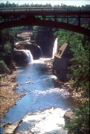
Glaciers from an ice age created the landscape along the byway. The mountains, lakes, and rivers were all affected by the presence of these great blankets of ice. The mountains were eroded and rounded, the lakes were filled to the brim, and the rivers ran away with the surplus water. The discovery of a whale skeleton on the shores of modern Lake Champlain is an indication of the vastness of the ancient glacial lake. The gorge now known as the Ausable Chasm is sandstone sculpted by the fast-moving Ausable River.
Today, Lake Champlain is one of the largest freshwater lakes in the world, full of many varieties of trout, bass, perch, pike, and other fish. And fish aren't the only kind of wildlife along the byway. Lakes to Locks Passage is host to a natural migration via the Atlantic Flyway. The Champlain Birding Trail allows you to watch for birds of all kinds as they migrate through the area. From Canada geese to red-winged blackbirds, creatures with feathers are well represented on the byway.
Recreational Qualities of Lakes to Locks Passage
The land that surrounds the Lakes to Locks Passage has been a vacation destination since the early 1800s, when it was part of "The Northern Grand Tour." Artists, writers, and the elite of the time would enjoy the scenery on a train ride or from a canal boat. Today, gazing out the car window is only the beginning. The Lakes to Locks Passage is a place for boating, bird-watching, biking, and diving beneath the surface of Lake Champlain. The waterways are the center of recreation here, but even if you don't like the water, you'll find plenty to do.
Waterways connect Lake Champlain to rivers and canals. Boaters will find access to this beautiful lake by the Champlain Canal, the Hudson River, or the Richelieu River of Quebec. Lake Champlain is the sixth largest freshwater lake in the United States, and the boating and fishing are superb. Boaters, kayakers, and windsurfers can all find communities with marinas, supplies, and places to relax. And if you don't have a boat, rentals and tours are available all along the lakeshore. Trout, bass, pike, or perch may be the reason you decide to take a boat onto Lake Champlain—fishing Lake Champlain is such a dynamic experience that experts participate in fishing tournaments held there. With 585 miles of shoreline, professional and amateur anglers can fish and enjoy a picnic on the shore of the lake.
The sights beneath the surface of Lake Champlain also interest visitors to the byway. America's best collection of freshwater shipwrecks can be found at the bottom of Lake Champlain, and diving is the best way to see them. You can find diving services as well as information on which sites are accessible. The Lake Champlain Underwater Historic Preserve and the Submerged Heritage Preserve are the places to start when searching for an exciting dive. Your dive may even include Champ, the legendary Lake Champlain Monster.
A name like Ausable Chasm just calls for adventure, and that is exactly what kayakers and rafters find as they travel down a two-mile stretch of the Ausable River. If you prefer exploring on foot, steel bridges afford a bird's-eye view of the chasm. You can cross from one end of the gorge to the other to observe massive rock formations or walk along the cliffs through a forest. On the edge of the Adirondack Park, this part of the byway is the perfect place for camping, hiking, or cycling. The Champlain Bikeway is one of the best cycling spots in the country. The route is nearly 360 miles long and goes through many parts of the byway and into Quebec. The walkways and bikeways allow you to see the byway and its recreational opportunities from several different perspectives.
Find more useful information related to New York's Lakes to Locks Passage:
- New York Scenic Drives: Lakes to Locks Passage is just one of the scenic byways in New York. Check out the others.
- How to Drive Economically: Fuel economy is a major concern when you're on a driving trip. Learn how to get better gas mileage.
Advertisement