Advertisement
An Inspiring and Iconic American Landscape
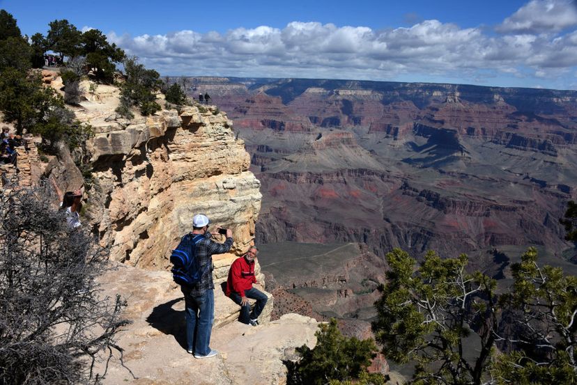
The Grand Canyon is as much a symbol of America as it is an icon among national parks. Established in 1919, the 1.2 million-acre park is one of the most visited in the system, attracting almost 4.5 million visitors every year.
Its resplendent, dusk light-catching walls — which display more than 2 billion years of the earth’s geological history — stretch 277 miles along the Colorado River. At 1.6 miles deep and up to 18 miles wide, it is one of the largest canyons in the world. Its 15 trails and surrounding historic districts provide many opportunities for hikers, bikers, and sightseers to take in the canyon’s awe-inspiring majesty. Adventurers can even brave the Colorado River’s rapids on single- and multi-day expeditions.
Long a favorite shooting location of Hollywood filmmakers, more than a dozen features have been filmed at the Grand Canyon, but the park had luminaries backing it long before the glory days of the silver screen. Naturalists, artists, progressives, and presidents helped shape the canyon politically, combining forces in the late 19th and early 20th centuries to set it aside for future generations. The park’s present grandeur is a resplendent and constant testament to their struggle and the traditions of conservation and preservation that sustains it.
Advertisement
Activities in Grand Canyon National Park
Scenic Canyon Drives, Walks, and Hikes With more than 1,904 square miles to its name, the Grand Canyon is so vast that you’ll want to check it out from more than a few different angles. Scenic drives along the canyon’s south rim make sightseeing incredibly convenient. Hermit Road and Desert View Drive are two popular routes that are open year-round, weather and road conditions permitting. But while driving is easy, there’s nothing quite like exploring the canyon rim on foot. Or better yet, hiking down into the canyon! Both the north and south rims provide access to numerous day hikes along the rim and into the canyon, which means that visitors can get an up-close look at its natural splendor without committing to a more challenging overnight trip. Ranger-led and guided educational day hikes are also available. Since the rims of the Grand Canyon have elevations of 7,000 to 8,000 feet, walking around can be very strenuous, especially on your way back up to the rim. Couple that with temperature extremes and few opportunities to fill up on food or water, and you’re looking a quite an adventure. As a rule of thumb, it will take you about twice as long coming out of the canyon as it will going down, due to the vertical climb. It is strongly discouraged to attempt trekking from the rim to the river and back in a single day. Rangers rescue hundreds of people from the canyon every year, so the park provides some important tips about hiking that apply even to the easiest trails. Visitors should also review special bulletins about hiking in the summer and in the winter. Overnight & Backcountry Hiking Overnight stays in the Grand Canyon are ideal for travelers in search of the simple pleasures of the wilderness: solitude and silence. There are 15 trails and a variety of routes to try, but unless you’re planning on staying in a developed campground, a backcountry permit is required. The park receives more than 30,000 permit requests every year, but only issues 13,000 permits, so it’s wise to book early to secure the itinerary of your choice. Review these stipulations before planning your trip. Park rangers recommend that first-timers venturing to the inner canyon stick to one of the Corridor trails (Bright Angel, North and South Kaibab) since they have to access to three campgrounds with emergency phones, water, and ranger stations. Phantom Ranch is the only place where visitors to the canyon floor are allowed to cross the Colorado River. The ranch’s famous rustic hostelry conveniently provides a break for those on overnight trips through the canyon. River Trips Whether you’re looking for whitewater adventure or scenic views from the canyon floor, river trips through the Grand Canyon offer a unique perspective on the park. Trips vary in length, from single-day outings to multiple-night camping trips, to highly technical rafting journeys that can last up to 25 days. Commercial (arranged through concessioners) and non-commercial (self-guided) options are available for trips involving more than one day of travel. Non-commercial trips require permits for travel on the Diamond Creek to the Lake Mead section of the Colorado River. Non-commercial trips for Lee’s Ferry to the Diamond Creek section of the river last 12 to 25 days and require permits awarded via weighted lottery. Applicants should review the park’s non-commercial river trip regulations before planning trips. Mule Rides Travel by mule in the Grand Canyon has loads of historical precedence. Since the park’s early days, the strong, sure-footed beasts have carried many visitors around the canyon, including President Theodore Roosevelt, an early champion of the Grand Canyon. Today, guests can tour the south rim and the inner canyon (to Phantom Ranch) on guided mule trips that depart from the park’s historic Bright Angel Lodge. North rim rides are offered as well, but they do not go to the Colorado River. Fishing While the Grand Canyon is home to several protected species of fish, anglers can try for trout, striped bass and catfish in Bright Angel Creek. The best seasons to go fishing in the creek are autumn and winter. State or non-resident fishing licenses are required, and artificial lure regulations apply to certain stretches of the Colorado River. Visiting Grand Canyon National Park Fees, Seasons, and Reservations The fee to enter Grand Canyon National Park is $25 per vehicle, or $12 for each individual arriving on foot, bike, motorcycle, or in a non-commercial group. The fee is good for seven days and grants access to the north and south rims of the canyon. Although the average distance between the canyons is 10 miles as the crow flies, a trip from one rim to the other involves a five-hour, 215-mile drive. The south rim is open all year and is far more tourist-friendly than the north rim. The north rim is closed from mid-October to mid-May since the road to it is usually blocked by snow. No visitor services, lodging, or other facilities are available during that time. In-season lodging is available at the historic Grand Canyon Lodge, as well as the Kaibab Lodge and the Jacob Lake Inn, which are outside of the park. The Grand Canyon Village in the south rim is home to several historic and contemporary lodges, as well as visitor information centers, museums, two restaurants (at Bright Angel and El Tovar lodges), and other amenities. A convenient bus transit system connects all the major accommodations and amenities in the village. Visitors are encouraged to make lodging reservations in advance. They can also fill out activities reservation requests, and request lodging at Phantom Ranch, which is located on the canyon floor and accessible only by foot or by mule. Bear in mind that these forms are requests and do not guarantee the options selected. After forms are submitted, a representative will contact the requester by phone or e-mail. Developed campgrounds are available on the north and south rims. An additional fee of $18-25 per campsite applies. Be sure to check road conditions before you come. Desert View Drive Scenic drives are among the most popular activities that visitors to the Grand Canyon partake in. Located east of the Grand Canyon Village, the Desert View Drive follows Highway 64 for 26 miles along the south rim, stopping at Grandview, Moran, Lipan, and Navajo Point overlooks before culminating at Desert View Point. Upon reaching their destination, visitors will find an information center and a watchtower that rises 70 feet above the canyon rim. Constructed in 1932, the tower was designed by architect Mary Elizabeth Jane Colter – who also designed the Bright Angel Lodge and other important park structures – and is meant to replicate the buildings of the ancient Pueblo people. Its interior features murals by the Hopi artist Fred Kabotie. The nearby Tusayan Ruin and Museum offers visitors a glimpse of the ancestral Puebloan culture. Hermit Road Closer to the Grand Canyon Village, Hermit Road was built by the Santa Fe company and opened as a scenic drive in 1912 — seven years before the Grand Canyon National Park was established. The eight-mile road boasts nine scenic overlooks, accessible by bike, foot, and tour bus. Visitors can hop on and off busses between stops to explore the rim or hike the road’s entire length. Be advised that while this and other south rim roads are open all year, icy conditions can close them suddenly during the winter months. Toroweap/Tuweep Area Overlook Named for a Paiute term meaning “dry and barren land,” the Grand Canyon’s Toroweap Area is preserved by the National Parks Service to reflect its natural condition. Opportunities for photography abound at the area’s sweeping overlooks, and there are several difficult trails for hikers in search of a challenge. Compounding the steep grades and lack of shade are a sparsity of visitor services. Even access — via country roads — can be trying, but the views of the Colorado River, Lava Flow Rapids, and the sheer, 3,000-foot drop to the canyon floor are well worth toughing it out. “Tuweep” is a name for the place used by early white settlers. It is thought to be derived from a longer Paiute word for “long valley.” Ranger Programs, Museums, and Visitor Centers The Grand Canyon might look empty, but it’s actually overflowing — with history! Joking aside, there is a lot to learn about the park’s natural and cultural history, and ranger-led programs are a great way to get informed. In addition to various guided educational hikes and tours, rangers ofter host talks at the park’s shrine of the ages. Travelers can also visit the canyon’s Pioneer Cemetery, where many important figures of the park’s past are interred. Various museums and visitor centers on the south rim also offer historical perspectives. Stop by the Yavapai Museum to learn about the canyon’s geology, or visit the restored studio museum of the Kolb brothers, the Grand Canyon’s pioneering photographers, and filmmakers. Wildlife in Grand Canyon National Park California Condors The trout-rich waters of the Colorado River make it an ideal habitat for bald eagles during the winter, but the most famous bird at the Grand Canyon is also one of the rarest bird species in the world — the California condor. With a featherless head and neck and a nine-foot wingspan, the homely scavenger might not be the prettiest bird in the sky, but beauty is in the eye of the beholder. Although the vulture’s range once extended from coast to coast — albeit in prehistoric times, when large animals were far more plentiful in North America — habitat reduction, shooting, and poisoning from lead and pesticides reduced its numbers to 22 birds by 1982. Drastic measures were taken to save the species in the mid-1980s when it was decided to take all remaining condors into captivity. The condors are slow to breed compared to other species, so breeding in captivity, protected from hostile external forces, helped bolster their numbers. Reintroduction to the wild began in California in 1992. The Grand Canyon region has been a principal site of California condor habitation since 1996, when six condors were released into the wild from captivity at Vermillion Cliffs, 30 miles from the park. Today there are about 70 condors soaring in the skies above the Grand Canyon. The park maintains an online condor bulletin board, including up-to-date population numbers and siting news. Mountain Lions Mountain Lions are a primary predator in Grand Canyon National Park. In 2003, National Park Service biologists began tracking mountain lions in the Grand Canyon using GPS and high-frequency radio tags. This research would help track mountain lion behavior and establish ranges for tagged animals, which in turn led to increased safety for both lions and park visitors. This work built upon an earlier survey of track counts and scent posts but was greatly expanded through the efforts of park service biologist Eric York, who initiated the practice of using radio collars to track mountain lions. York’s “skill with trapping techniques and compassion in handling captured cats was key to the successful implementation of the telemetry program,” according to the park’s website. Tragically, York succumbed to the pneumonic plague that he likely contracted from the infected carcass of a mountain lion that he had brought into autopsy in 2007. Lion capture in the park has since been suspended as the park service develops safeguards for researchers. Humpback Chub Prior to the completion of the Glen Canyon Dam, native populations of fish thrived in the waters of the Colorado River in the Grand Canyon. The species native to the area, such as the humpback chub, had adapted to the intense seasonal fluctuations in temperature and other conditions in the river. Regulation of those conditions due to the dam, and increased competition from non-native species like trout have had a profound detrimental impact on the chub and other native fish in the park. Once ubiquitous in the Colorado River, the chub’s numbers have dwindled so low that the fish was put on the federal endangered species list. A ban on fishing chub and a program of translocation of juvenile fish from its native habitat to Shinumo Creek, a tributary of the Colorado River are two countermeasures that have been taken on its behalf. History of Grand Canyon National Park Geology Exactly when the Grand Canyon started to form is a topic of some debate among scientists. Traditional, conservative estimates place its origins within the last five to six million years, while uranium-lead dating suggests that the canyon might be more than 17 million years old. Two major geologic events helped shape the canyon. As the Colorado Plateau was pushed upward due to mountain formation, the grade of the Colorado River became steeper. The river eroded the rock to form the canyon, which proceeded at an accelerated rate due to the uplift. Today, amazing bands of the North American substrata can be seen on the canyon wall. The exposed rock reveals more than two billion years of the Earth’s geologic history. Native Peoples Human habitation of the Grand Canyon region dates back 12,000 years when a culture known as the Ancestral Puebloans was active in the area. Known for their construction of adobe structures (“pueblo” is the Spanish word for “village”), the Ancestral Puebloans were the first to inhabit the canyon, where the ruins of ancient granaries that they built still exist today. It is thought that today’s Pueblos are descended from the Ancestral Puebloans, a belief commonly upheld by members of that tribe. The Ancestral Pubeloans are sometimes called “Anasazi” by archeologists, a name that is derived from a Navajo word for “Ancient Ones” or “Ancient Enemy.” Understandably, that term is disliked by the Pueblos. Other native peoples have inhabited the canyon as well. Among them are the Cohonina, a pottery-producing agricultural culture that was ancestors of the modern-day Havasupai and Hualapai. The latter groups are heavily involved in tourism in and around the Grand Canyon. Spanish and American Exploration The first record of a European visiting the Grand Canyon was in 1540 when the conquistador García López de Cárdenas was led to the rim by Hopi guides. His party failed to reach the canyon floor, turning back due to a lack of drinking water. It would be more than two centuries before another group of Spaniards, this time soldiers, and priests in search of a route between Santa Fe and California would explore the canyon’s north rim. Mormon pioneers and missionaries to the region established good relations with the native population in the 1800s. This relationship would be crucial to further American exploration of the area, ensuring safe passage for later expeditions that sought to explore the Colorado River. Westward expansion led to conflict between capitalists and pioneers regarding the use of the land. The latter group had forged settlement in the country, while the former saw its industrial potential. Becoming A National Park In the decades following the Mexican-American War, tensions in the region galvanized along the lines of those who wished to preserve the region and those who would exploit it. This friction was egged on by the era’s progressive political zeitgeist, which railed against unchecked capitalism. Progressivism favored a scientific and democratic government response to the profit motive, which included the protection of America’s natural resources. While some forward-thinkers took the long view of conservation, other area residents were equally mistrustful of both corporations and federal meddling in their affairs. Ultimately, conservationism would win out, but granting the park full protection would be a long struggle. One vital move came in 1903, when President Theodore Roosevelt, who was known for his prowess as an outdoorsman and stance as a conservationist, visited the Grand Canyon. He would establish a level of protection for the park as a game reserve in 1906, and add adjacent national forest lands to create the Grand Canyon National Monument in 1908. The latter move was unpopular with landowners and mining interests, and both groups would oppose the establishment of a national park for more than a decade. The Grand Canyon finally became a national park in 1919. Civilian Conservation Corps If the first President Roosevelt was a champion of protecting the Grand Canyon, then the second was a key figure in improving its facilities. The Grand Canyon benefited greatly from the projects of President Franklin Delano Roosevelt’s Depression-era Civilian Conservation Corps, which worked in the park from 1933 – 1942. The corps built structures, improved trails, and landscaped the south rim’s Grand Canyon Village.
Advertisement