A Guide to Hiking Rocky Mountain National Park

By: Becky Striepe
Snow-capped mountains, pine trees and pristine lakes
Snow-capped mountains, pine trees and pristine lakes define the Rocky Mountains.
Comstock / Thinkstock
He climbed cathedral mountains, he saw silver clouds below
He saw everything as far as you can see
-- Rocky Mountain High

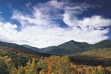
Pop singer John Denver wrote these lyrics after moving to Colorado and experiencing the beauty and wonder of the Rocky Mountains. (Colorado later returned the favor by making it an official state song). And Denver was not the only one so transformed. Every year 3 million people come to Rocky Mountain National Park to experience the unique views that come with hiking at a high elevation, making it one of the most popular national parks in the U.S.

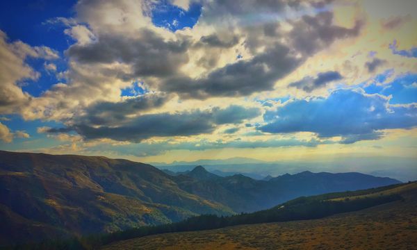
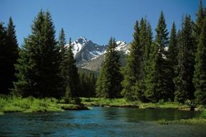
Located just 80 miles (128 kilometers) north of Denver, Colorado, Rocky Mountain National Park is the highest park in the country [sources: GORP, Schmidt]. The elevation means that some of the peaks have snow year-round, but cold weather hiking isn't the only attraction. You can hike through the woods or head up to higher elevations for even better views. You hit the tree line at around 11,000 to 11,500 feet (2,700 to 3,650 meters), and here the landscape changes dramatically from a forest of pines to open expanses of wildflowers, because the temperatures at this altitude are too cold for most trees to grow [source: National Park Service].

Advertisement

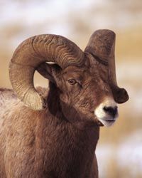
Wildlife viewing is also affected by what elevation you're hiking. You can find bighorn sheep, coyotes and elk both above and below the tree line, but some of the best wildlife is located in Moraine Park and Horseshoe Park, especially in October during elk mating season [source: GORP]. Horseshoe Park's Sheep Lake also features a large mineral deposit that's basically a naturally occurring salt lick that attracts big horn sheep.

Although home to humans for 10,000 years, Rocky Mountain National Park became part of the National Park Service in 1915, despite controversy. Ranchers, mining companies and developers at the turn of the century opposed any move to preserve land from private use, just like today [source: National Park Service]. Fortunately the NPS preserved the park to be enjoyed by future generations.

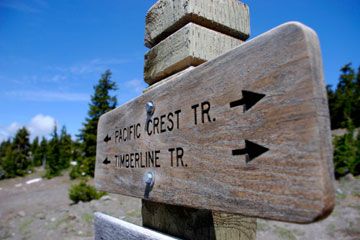
Whether you're headed out to Rocky Mountain National Park for a day hike, a weekend of hiking and camping, or a longer backpacking trip, it's important to know where you're going and keep an eye on trail conditions, so that you can bring the right gear for your trek. We'll look at some popular trails next.

Advertisement

Rocky Mountain: Trail Maps

Bighorn sheep are attracted to the natural salt lick at Horseshoe Park in the Rockies.
Stockbyte/Thinkstock

Rocky Mountain National Park has trails for a wide range of skill levels, so whether you're a novice or an experienced hiker, you can find a trail that's doable for you. You can choose your trail by difficulty or by distance, but because of the drastic changes in elevation, distance can be a little misleading. A 1.5 mile (2.4 kilometer) hike might seem like a piece of cake, but it's not so easy if the change in elevation is 1,200 feet (366 meters), like Butler Gulch [source: RockyMountainNationalPark.com]. Consulting a good trail map or a resource that lists trails by difficulty can help you make sure that you know what you're getting into before you get to the trailhead. RockyMountainNationalPark.com has trails organized by difficulty and by region, so you can find a trail that's good for you.

There are hundreds of miles of trails in Rocky Mountain National Park, but if you want to check out the three most popular routes, head to the Bear Lake Trailhead [source: Let's Go]. Seasoned hikers can do the four-mile (6.4-kilometer) one-way hike up to Flattop Mountain, where you can hike up beyond the tree line to the arctic tundra and see the Continental Divide in all its splendor. For an easier hike, take the trail to Nymph, Dream and Emerald lakes, which are actually glacial pools and offer some stunning views. If you're feeling adventurous, take the two-mile (3.2-kilometer) trail to Lake Haiyaha, which is a moderate hike through the forest until you get close to the lake, where you'll need to climb up some steep rocks to get to the lake itself.

Advertisement

If you're planning to camp along the way, look for trails that meet up with campgrounds. At Rocky Mountain National Park, you're only allowed to camp at designated campgrounds. Backcountry and cross-country camping does require a special permit, and only seven campers can occupy a campsite at once, to help preserve the fragile ecosystems in the backcountry. If you're doing backcountry hiking, there are official backcountry campsites, and you need to register in advance to camp in the backcountry.

The National Park Service (NPS) has some basic trail maps, including a Backcountry Site Map, so when you're planning your trip, that's a great place to start. They sometimes close areas to preserve those habitats, and you can find a list of most closures on the NPS website. It's a good idea to check in at a visitor center when you arrive, since they'll have the most up-to-date list of closures.

Trail maps are a big help when you're planning your hike, but it's also important to look at trail conditions before you head out to make sure the area where you're planning to head is safe for hiking.

Advertisement

Rocky Mountain: Trail Conditions

Like any trail, conditions in Rocky Mountain National Park can vary depending on time of year and weather. Not all hazardous trail conditions have to derail your hiking plans, but you might need special gear, depending on what's going on with the trail you want to hike.

The main natural causes of dangerous trail conditions are:

Advertisement

Fallen trees: These can make a trail impassable, but if the downed trees aren't too big you can sometimes scramble over them.

Ice: If you're going to hike an icy trail, it's a good idea to bring traction devices, usually some kind of chain that straps to your shoe, to help you walk on slippery terrain.

Snow: If there's just a bit of snow, waterproof hiking boots and maybe a traction device can do the trick. For areas with a lot of snow, you might consider snow shoeing! Pick up a pair of snow shoes and telescoping poles to help you keep your balance, and you can head out on even a snowy trail [source: Backpacking.net].

You might think of snow and ice as winter hiking conditions, but because of the elevation some trails in Rocky Mountain National Park have snow year-round, and conditions at this altitude can change quickly. It's a good idea to check trail conditions to make sure you have the right gear. Hiking in the snow without waterproof boots, for example, is uncomfortable at best and can be dangerous at worst. No matter when you're hiking or what the trail conditions, rain gear is a must. You don't want a surprise shower upping your risk for hypothermia.

Looking for information on trail conditions? The National Park Service maintains a list of user-submitted trail conditions, where hikers and volunteers fresh off of the trail can give current information about downed trees, icy trails, snowy conditions, and other possible trail hazards.

Advertisement

Rocky Mountain: Thrill-Seekers' Tips for Off-Trail Hiking

Looking to head off the beaten path in Rocky Mountain National Park? Going off-trail can be a magical experience. When you ditch the trail, you leave the crowds behind, and there are some great vistas off-trail. One breathtaking off-trail destination is the summit of Steep Mountain, where you can see the Continental Divide, the picturesque line of mountains where rivers flow to the Atlantic Ocean on the east side and the Pacific on the west [source: Summit Post].

If you're not an experienced hiker, going off-trail can be dangerous. It's a good idea for newer hikers to find a tour company that offers some off-trail hiking, so you'll have a guide to help you find your way, especially through the forested areas where it can be easy to get lost.

Advertisement

It's also a good idea to consider a handheld GPS when you're hiking off-trail. This can help you find the trail if you lose your sense of direction in the woods. Whether you choose a GPS or not, it's also important to use a map. Check out a map of the off-trail area you're planning to hike before heading out, so you'll have a good idea of where you're going.

Since off-trail areas are less crowded with people, there's often more wildlife. This is usually a good thing, but you need to stay aware in case you encounter bears, moose, or other large animals that can harm you. Normally these creatures won't bother you if you don't bother them, so keep an eye out!

When you go off-trail, you're venturing into fragile habitats, so be considerate. Taking anything out of a national park is taboo, and even more so when you're off the trail. Off-trail hikers are more likely to cause damage, since the whole idea behind trails is to provide a path to prevent us from trampling delicate plants and animal habitats.

Advertisement

Author's Note

I haven't done a ton of cold-weather or high altitude hiking, but I can tell you that when folks mention having the right gear, they are not messing around. I still remember a trip that my family took to Mount Rainier in Washington State. We hiked off-trail because another hiker mentioned that he'd seen a momma fox and her cubs not too far from where we were.

My family is from South Florida, and we had no idea what cold really meant. We thought we'd be fine in our jackets and cheapo hiking boots. What a terrible idea! It is tough to enjoy beautiful scenery, even a brand new family of foxes, when you can't feel your toes. Luckily, it was not a long hike up and back, so we made it safely. I had no idea until much later that our little trip out into the snow was so risky!

Advertisement

Related Articles

Sources

  • Backpacking.net. "The Winter Backpacker." (May 11, 2012) http://www.backpacking.net/winter.html
  • GORP. "Rocky Mountain National Park." September 15, 2010. (May 11, 2012) http://www.gorp.com/parks-guide/travel-ta-rocky-mountain-national-park-colorado-sidwcmdev_067884.html
  • Leave No Trace. "The Leave No Trace Seven Principles." Center for Outdoor Ethics. (May 21, 2012) http://lnt.org/learn/7-principles
  • Let's Go. "Rocky Mountain National Park Overview." (May 29, 2012) http://www.letsgo.com/1892-colorado-travel-guides-rocky_mountain_national_park-d
  • nationalatlas.gov. "Continental Divide of the United States." USGS. (May 21, 2012) http://nationalatlas.gov/mld/condivl.html
  • RockyMountainNationalPark.com. "Butler Gulch." (May 21, 2012) http://rockymountainnationalpark.com/trails/butler_gulch.html
  • RockyMountainNationalPark.com. "Hiking." (May 11, 2012) http://rockymountainnationalpark.com/pages/hiking.html
  • Rocky Mountain National Park. "High Country Hazards." National Park Service. (May 21, 2012) http://www.nps.gov/romo/hicountry_hazards.htm
  • Rocky Mountain National Park. "History & Culture." National Park Service. (May 11, 2012) http://www.nps.gov/romo/historyculture/index.htm
  • Rocky Mountain National Park. "Maps." National Park Service. (May 11, 2012) http://www.nps.gov/romo/planyourvisit/maps.htm
  • RockyMountainNationalPark.com. "Plants." (May 21, 2012) http://www.nps.gov/romo/naturescience/plants.htm
  • Schmidt, William E. "What's Doing in Boulder." The New York Times. November 28, 1982. (May 29, 2012).http://www.nytimes.com/1982/11/28/travel/what-s-doing-in-boulder.html?pagewanted=all
  • Summit Post. “Tour de Steep Mountain.” March 27, 2009. (May 21, 2012). http://www.summitpost.org/tour-de-steep-mountain-rocky-mountain-national-park-colorado/493489
  • Widman, Carolyn Grace. “Discouraging Off-Trail Hiking to Protect Park Resources: Evaluating Management Efficacy and Natural Recovery.” Virginia Polutechnic Institute and State University. June 24, 2010. (May 11, 2012) https://docs.google.com/viewer?a=v&q=cache:9hsTy6myJ2QJ:nr.ncr.vt.edu/major_papers/Carolyn_Widman.pdf+&hl=en&gl=us&pid=bl&srcid=ADGEESjiqwjMeG1pHP4U9ACWq5sIEO4bmRebP7Yz7QeGig8lW_TSXrNcRiqggKipu5ZQN94mJNIhVzkOt5QqhqCYqoNE9D_G72y9iV8ABvzY-XgEw-ZJTY42KczQscM1V_38lJa71aS0&sig=AHIEtbSgKnmD4wB8_V36ZvxlnYfRi7H_mg

Advertisement

Advertisement

Loading...