A Guide to Long Trail Hiking

By: Becky Striepe
green mountains
A small cascading waterfall flows down the rocks in the Green Mountains of Vermont.
Ron and Patty Thomas /Photographer's Choice/Getty Images

When forester Benton Mackaye was conceiving the Appalachian Trail in 1921, he drew inspiration from an earlier path – Vermont's Long Trail [source: Compos]. The first long-distance hiking trail in America, the Long Trail is a beautiful but tough hike over dozens of mountains, and for many seasoned hikers, completing its entire 273-mile (439-kilometer) length is a badge of honor.

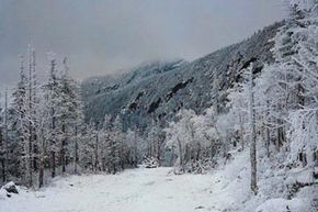
The Green Mountain Club, a group of local conservationists, established the trail between 1910 and 1930, and they maintain it to this day [source: Green Mountain Club]. The south end of the trail is right on the Massachusetts/Vermont border and it cuts straight up the middle of the state through the Green Mountains, ending at the Vermont/Canada border. The trail heads through lush wooded areas, over mountain peaks where you can see the stunning Green Mountains, and even dips up into arctic tundra at a couple of points. The Long Trail is popular for its areas of unspoiled wilderness, dramatic changes in elevation, and for the path over Mount Mansfield, the highest mountain in Vermont [source: SummitPost].

Advertisement

The Green Mountain Club also maintains nearly 70 primitive shelters along the trail to accommodate camping, and they're savvily spaced so that you can hike from one to the next in just a day. That means you can camp in shelters all the way from Massachusetts to Canada, which is pretty handy! You still need camping gear, of course -- especially if you're thru-hiking -- but the shelters keep you dry and out of the mud if you hit inclement weather on your hike. The Long Trail can get pretty muddy from snow melt and rain, so a dry place to camp is a definite plus [source: Werner]!

Day hikers can take up-and-back routes to landmarks along the way or map out loops that take them down side trails without having to double back. If you're looking for something longer than a day hike, good trail maps are a must.

Advertisement

Long Trail Hiking: Trail Maps

snow on green mountain
Hikers need to avoid high elevations in the early spring through Memorial Day because snow melt causes muddy conditions. Still the snow does look beautiful.
Stockbyte/Getty Images

The Long Trail has blazes – markings painted on trees or signs – to help you find your way. Blazes for the Long Trail are white, and side trails have blue blazes [source: Green Mountain Club]. You can most likely follow blazes and signs on a shorter hike, but for any kind of distance hiking, you'll want a trail map on hand.

Your best option is probably purchasing the Green Mountain Club's waterproof trail map. It's only $10 and has information not just on trails and landmarks but also on elevation and shelters. The proceeds benefit the Green Mountain Club which maintains the trail. If you're going to be doing a lot of Long Trail hiking, you can also become a member of the Green Mountain Club. Membership starts at $40 for individuals, and Green Mountain Club members get a 10 percent discount on items in their store, including their maps.

Advertisement

There are also a couple of free resources for maps that you can use instead:

  • Postholer.com – At Postholer, you can check out a map of the Long Trail as well as many other popular hiking trails. The interactive map not only shows the route, but also topography and satellite views and you can zoom in on the areas where you're planning to hike and look for important landmarks like mail drops.
  • Backpacker – If you want to find routes by distance and difficulty, this is the site for you. You can choose any section of the trail you like, and it includes an interactive map where you can zoom in and examine your route in detail.

Just remember that not all of the Long Trail has cell coverage, so you don't want to rely on your smart phone or the Internet alone for your map. Make sure you have a physical copy, so you'll always know where you are and where you're heading. For longer hikes you might want to invest in a handheld satellite GPS to help you find your way if you get turned around in the woods.

Advertisement

Long Trail Hiking: Thru-Hikes

If you're an experienced hiker looking for a challenge, thru-hiking the Long Trail might be just the thing! Thru-hiking or end to end hiking refers to hiking long trails from start to finish. It takes about 26 to 30 days to hike the Long Trail's entire 273-mile (439-kilometer) length [source: Green Mountain Club].

Thru-hiking the Long Trail means packing the right gear. Because of the elevation, you'll want to bring cold-weather supplies no matter when you're going. The basics you'll need are: a tent, a sleeping bag that's rated for chilly temperatures, a lightweight backpack, some light rain gear, and light cooking gear [source: Tapon]. Notice the emphasis on "light?" You'll be grateful for every pound you shave from your backpack. You'll also want to pack a few essentials like a change of socks and underwear and a small first aid kit with bandages for cuts and blisters and disinfectant.

Advertisement

One season that hikers in many other states don't generally have to plan for is what Vermonters lovingly call "mud season." Green Mountain Club asks hikers to avoid high elevations in the early spring through Memorial Day each year, because snow melt causes muddy conditions that are dangerous to hikers and make the alpine tundra portions of the trail fragile. While these severe muddy conditions dissipate after Memorial Day, you need to plan for some soggy, muddy walking no matter what time of year you hit the Long Trail. That means choosing waterproof hiking boots and thick socks to keep your feet warm and dry.

You'll want to pack plenty of food, but also plan some food drops along the way. You can ask friends and family to ship non-perishable food to some of the post offices along the route, or you can break from the trail and hike into town to grab more supplies at one of the points where the trail passes close to civilization.

Advertisement

Long Trail Hiking: End to End Hiking

If you're going to take a month to thru-hike the Long Trail, you probably want something to show for it, right? The Green Mountain Club offers an official End to End Certification for hikers who have made it all the way from Massachusetts to Canada on the trail.

To qualify for End to End Certification, you need to fill out an application, keep a trail journal and pare it down to ten pages when you finish your hike. Green Mountain Club is looking for descriptions of your journey, not just a list of where you were and when. They read each journal that's submitted, so have fun with it! Did you see a black bear? What was it like crossing the treeline into the arctic tundra? They want to hear about the vistas you saw and the animals and people you met along the way.

Advertisement

End to End Certification comes with a free one-year membership to Green Mountain Club, and they send you some swag and publish your name and address in their summer newsletter [source: Green Mountain Club]. They've certified over 3,100 hikers so far, and the Vermont Historical Society archives every single one.

Hiking from end to end has its share of challenges. The southern end of the Long Trail is also part of the Appalachian Trail, the longest hiking trail in the U.S. [source: Hiking the Smokys]. It's a busy path that's not too rugged. After that first 100 miles (161 kilometers) or so, the topography starts changing as climbs get steeper and you begin hitting some of the higher peaks along the way [source: Restless Adventurer]. Along the way you'll trek through wilderness, forests, tundras, and majestic mountaintop views.

One of the trickier parts for thru-hikers is sorting out transportation: how will you get from your home to the trailhead, and how will you get back home when you finish your end-to-end hike?

Advertisement

Long Trail Hiking: End to End Transportation

fog on green mountain
A nice shot of fog over the Green Mountains.
VisionsofAmerica/Joe Sohm/Photodisc/Getty Images

It may seem out of place to talk about transportation when you're talking about hiking, but end to end transportation is an important detail when you're planning any thru-hike. You need to figure out not only to get to the trailhead but also how to get home once you reach the other side. The Green Mountain Club has an End-to-Enders guide for sorting out your travel at either end of the trail. If you're not up for purchasing the guide, here's some basic end to end transportation information to help you get to and from the Long Trail.

North to South Transportation

Advertisement

The best way to hit the Long Trail is to come via the major cities on either end, then make your way to the trailhead. If you're planning to hike the Long Trail from north to south, your best bet is flying into Burlington, taking the 90 minute cab ride to North Troy, and then hitting the trail from there. You can also take the bus or Amtrak to Burlington. When you get to the south end, Peter Pan Bus Lines from Williamstown, Mass. to the New York Port Authority, where you can take transit to one of New York's airports or hop on a bus or Amtrak to head home [source: Compos].

South to North Transportation

To get to the trail's south end, you'll need to make your way to Williamstown, Mass., and the easiest way to do that without a ride is taking Peter Pan Bus Lines from New York City's Port Authority straight into Williamstown. At the north end, when you get to the Canadian border, it's a short walk (one mile/1.6 kilometers) back to North Troy, where you'll catch a cab or a shuttle back to Burlington.

Advertisement

Long Trail Hiking: Popular Routes

Not up for end to end hiking? That doesn't mean you have to miss out on the beauty of The Long Trail. There are plenty of day hikes and other short routes that you can take to enjoy The Long Trail without thru-hiking.

The portion of the Long Trail that follows Mount Mansfield is popular because of its elevation. About 2.3 miles (4 kilometers) of the trail are above the treeline, with majestic views and even a stretch of Arctic Tundra. Summit Post lists a few routes that you can take to Mount Mansfield, depending on what kind of scenery you're after.

Advertisement

For an easy there-and-back hike with gorgeous views, check out Mount Abram in central Vermont. The five mile (8.4 kilometer) roundtrip should only take about three to four hours and is a good route if you're planning to hike with kids [source: Partsch]. The trail ends at the mountain's summit, where you get a 360 degree view of the Green Mountains. After you soak up the views at the peak, just turn around and head back down the mountain the same way you came up.

Near Huntington, Vermont, the Burrows Trail – a side trail off of the Long Trail - is a popular route up through Camel's Hump State Park. Burrows Trail ends at the Long Trail, and from there it's a short walk up the Long Trail to the summit, where you can get some great views of the Green Mountains [source: Summit Post].

If you're looking for a longer trip, Backpacker Magazine recommends a week-long, 50 mile (80.5 kilometer) hike from Camel's Hump that ends at Long Trail Tavern, a bar in Johnson, Vermont. Really, what's better after a week of backpacking than some pub food and a cold beer? Long Trail Tavern even has a signature brew: Long Trail Ale [source: Emert].

Advertisement

gpAuthor's Note

My friend Jon Beckham, who I mention in this article, thru-hiked the Appalachian Trail (AT) a few years ago, and it sounded like a magical experience. While the Long Trail takes about a month to thru-hike, the AT takes five to seven depending on your skill level. Not everyone who starts the AT finishes, and Beckham actually started the hike with his dad who had to bail before it was over. One of the things that stuck with me about his story was how much peanut butter he ate. To hear Beckham tell it, long distance hiking is best fueled by peanut butter, and I have a mental image of him eating peanut butter out of the jar just like Pooh Bear ate from his hunny pot.

Related Articles

Advertisement

Sources

  • Compos, Jamie. "Hiking the Long Trail – Vermont." Down the Trail. 2007. (May 28, 2012) http://www.downthetrail.com/hiking-the-long-trail-vermont/
  • Emert, Jarett. "The Works: Hike Vermont's Long Trail." Backpacker. September 2008. (May 29, 2012) http://www.backpacker.com/september_08_vermont_long_trail/destinations/12547
  • Green Mountain Club. "End to End Certification." (May 29, 2012) http://www.greenmountainclub.org/page.php?id=106
  • Green Mountain Club. "History of the Long Trail." (May 28, 2012) http://www.greenmountainclub.org/page.php?id=15
  • Green Mountain Club. "The Long Trail." (May 28, 2012) http://www.greenmountainclub.org/page.php?id=2
  • Hiking the Smokys. "Appalachian Trail Guide for Great Smoky Mountains National Park." (June 12, 2012) http://www.hikinginthesmokys.com/appalachiantrail.htm
  • Partsch, Frank. "Hiking Central Vermont." Central Vermont. (May 28, 2012) http://www.central-vt.com/visit/hiking.htm
  • Restless Adventurer. "Thru-Hiking the Long Trail." October 2005. (May 29, 2012) http://www.restlessadventurer.net/backpacking/long-distance/long-trail/lt_intro.php
  • SummitPost. "Burrows Trail." September 29, 2008. (May 29, 2012) http://www.summitpost.org/burrows-trail/167210
  • SummitPost. "Mount Mansfield." November 4, 2009. (May 29, 2012) http://www.summitpost.org/mount-mansfield/150938
  • Tapon, Francis. "Backpacking versis Thru-Hiking." Backpacking Light. September 20, 2009. (May 29, 2012) http://www.backpackinglight.com/cgi-bin/backpackinglight/backpacking_v_thruhiking.html
  • Werner, Philip "Mud, Glorious Vermont Mud." SectionHiker. (May 28, 2012) http://sectionhiker.com/mud-glorious-vermont-mud/

Advertisement

Advertisement

Loading...