10 Sprawliest Cities in the United States

By: Chris Opfer
multicar accient, Las Vegas
A mulitcar accident clogs roads in Las Vegas, one of the sprawliest cities on our list.
David Becker/Getty Images

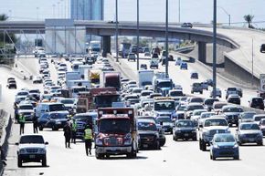
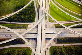
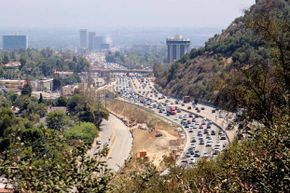
In Jacobellis v. Ohio, a 1964 Supreme Court case concerning a criminal law against "hard-core pornography," Justice Potter Stewart famously wrote that while he could not intelligibly define the term, "I know it when I see it" [source: urban sprawl, a concept that for some is just as offensive and equally hard to explain, mostly because everyone seems to have a different definition for the term. The hallmarks include bad traffic, a flurry of strip malls and an "out, not up" development strategy, but ultimately sprawl is in the eye of the beholder.

Essentially, sprawl is the spreading of a city and its suburbs. Or, as the Oxford English Dictionary puts it, "the straggling expansion of an indeterminate urban or industrial environment into an adjoining countryside." Whether or not it is a good thing remains the subject of debate among city planners, political leaders, environmentalists and folks who don't like sitting in bumper-to-bumper traffic. Some claim that sprawl has helped reduce a "consumption gap" among races, while others simply contend that compact development is not the cure for traffic woes. What's clear is that sprawl is happening in cities and regions across the U.S., encouraged by factors like poor planning, zoning laws and Americans' dependence on cars [sources: Gilroy, Hess].

Advertisement

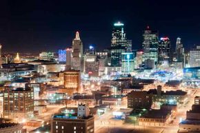
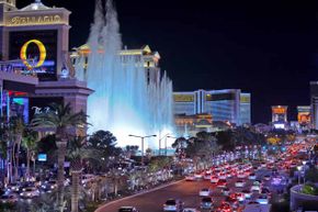
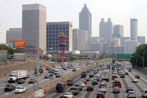
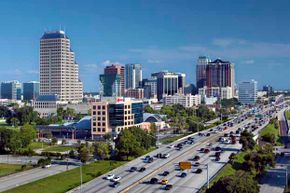
Read on for a peak at the sprawliest cities of them all.

10: Kansas City

Kansas City at night
Kansas City is home to the most freeway lane miles per capita among metro areas with more than 1 million residents.
Rowly Emmett/Flckr/Getty Images

Kansas City's sprawl is so unmanageable it spans two states: Missouri and Kansas. Despite a vibrant downtown that features a heavy heaping of arts and culture to go along with all of the barbeque options, the people of this city have been moving farther and farther away from the center of town over the years. While the city's population grew by 29 percent over two decades from 1970 to 1990, its land consumption grew by a whopping 110 percent during the same period [source: River Network].

Of course, all those people spread across all that land need a way to get around. K.C. is now home to the most freeway lane miles per capita among metro areas with more than 1 million residents, boasting about 1.2 miles (1.9 kilometers) of road for every thousand residents [source: Urbanophile]. It appears that city officials intend to hold on to this distinction. The $600 million Johnson County Gateway project will expand a number of major interstates and the flyover sections where they come together in an effort to accommodate more commuters coming into the city from farther away. Not everyone is a fan of the massive undertaking: The Kansas City Star recently dubbed it "the project from hell, supposedly paved with good intentions" [source: Abouhalkah].

Advertisement

9: Washington, D.C.

occupy DC, traffic
Demonstrators from the Occupy DC movement shut down rush hour traffic as they march through downtown Washington.
Chip Somodevilla/Getty Images

The nation's capital city is a mere 60 square miles (155 square kilometers), but with daily commuters coming from as far away as Delaware and West Virginia, the D.C. metro area is a monstrosity of sprawl. In fact, so many businesses and the folks who work for them have wandered outside the city limits that some have recently argued that the area's commercial center is suburban Fairfax County Virginia, rather than the District proper [source: O'Connell].

The federal city is a different animal than the other entrants on this list, given its size, lack of representation in Congress and overflow of temporary, carpet-bagging residents. One thing the District shares with the big boys, however, is big traffic. Washington metro area drivers spend an average 70 hours a year stuck stuck in congestion on the roads, some of which is likely a product of sprawl, tying the region with the Chicagoland area for most hours wasted behind the wheel due to congestion [source: Texas A&M].

Advertisement

The coming extension of Metro train service to Dulles Airport and beyond into Leesburg, a once quaint and quiet little town that has transformed into a booming exurb in the last two decades, is aimed at easing the pain of commuting in and around D.C., but some say it may just extend the sprawl further into the Virginia countryside [source: van Zuylen-Wood].

8: Detroit

downtown Detroit
The big decline in Detroit's population in the past decade has been due to people moving to the suburbs -- which means lots more commuters.
Tom Carter/Photolibrary/Getty Images

Perhaps no major American city was harder hit during the recent recession than Detroit, the country's automotive capital, which has crumbled in the wake of disappearing factory jobs and a glut of home foreclosures. The city's population fell by 25 percent in a decade to just over 713,000 in 2011, the fewest residents Detroit has seen since 1910 [source: Linebaugh].

That's not a lot of people for a city that spans about 140 square miles (363 square kilometers), more space than Manhattan, Boston and San Francisco combined. It might seem like everyone is fleeing Detroit, but the truth is that most are simply moving to the suburbs [sources: Maynard, Linebaugh].

Advertisement

Which, of course, means more traffic. Not only are commuters coming into the city from farther out, but the population drain over the past 10 years has decimated tax revenues, some of which would have gone to infrastructure and public transportation. Forbes ranked Detroit as the second worst commuting city in 2010, noting that a mere 12 percent of commuters walk, bike, carpool or use public transportation to get to work [source: Levy].

7: Las Vegas

las vegas bld, bellagio
A night view of the Bellagio hotel fountains and the traffic on South Las Vegas Boulevard.
san francisco photographer/Flckr/Getty Images

Sin City's rapid outward growth is so stark that NASA recently released a time lapse video of satellite footage documenting the booming expansion over the last 40 years. From 1972 to 2010, the Las Vegas metro area has seen its population grow from slightly under 300,000 to almost 2 million as more residents moved further away from the city proper. Las Vegas-Paradise Metropolitan Statistical Area currently spans all of Clark County, a 7,891 square mile (20,438 square kilometer) tract. Meanwhile the average driver loses 28 hours to traffic congestion [sources: U.S. Census Bureau, Texas A&M].

The unprecedented growth has taken its toll on Vegas, particularly when it comes to infrastructure issues such as maxed out roadways and overcrowding in schools. Then came the recession. Like a fella at a blackjack table who goes all in only to be dealt a pair of threes, home owners and developers found themselves overextended when the bottom fell out of the economy in 2007. The good news is that the half-built subdivisions pock-marked with vacancies and foreclosures that dominated the area during the recent recession are starting to be turned around as part of a short-sale infused transition in the local housing market. [sources: Museum of the City, Coolican, Smith].

Advertisement

At the same time, the city is doubling down on efforts to develop and revitalize its urban center, including the downtown area. In addition to Symphony Park, a 61-acre mixed-use urban community currently under construction, online shoe retailer Zappos is moving at least 1,200 employees from nearby Henderson to a new $350 million downtown community later this year. The idea is to build a neighborhood where Zappos employees and others can live, work and play [sources: Joffe-Block, Gallagher].

6: Atlanta

Atlanta traffic
In view of the Olympic torch, traffic crawls through downtown Atlanta along Interstate 75/85 during rush hour.
Barry Williams/Getty Images

The ATL is many things -- pleasantly slow paced, modern, metropolitan, hot -- but it is also sprawling. The 131-square mile (331 square kilometer) city itself is large enough that it spans two counties, Fulton and Dekalb. That's not to mention the greater metro area, which runs more than 8,000 square miles (20,720 square kilometers) [source: Invest Atlanta].

With no natural barricades, such as large bodies of water or mountains, nor federal land holdings to limit the city's outward growth, Atlanta is likely to continue to grow horizontally. Indeed, the proof is in the permits. One way in which people who study these things attempt to gauge sprawl is based on housing density. The more single family homes being built, the more likely people are to be spread farther out, the logic goes. Last year, a whopping 72 percent of the 8,634 new residential building permits issued in Atlanta were for single-family dwellings [sources: Kolko].

Advertisement

Recent Census data showed that population in the city of Atlanta grew at a faster rate (2.4 percent) than that in the surrounding metro area (1.3 percent). Yet given that just more than 432,000 folks were living in the city last year, compared to more than 4.9 million in the 'burbs, total growth in the surrounding area continued to greatly outpace that within the city limits. Meanwhile, Atlanta also ranked third on Forbes' 2010 list of worst commutes [source: Levy].

5: Orlando

Orlando skyline
The Orlando skyline rises above the traffic on Interstate 4, a highway that runs east to west through central Florida. The area surrounding the highway is often referred to as the "I-4 Corridor."
John Coletti/Photographer's Choice/Getty Images

There are plenty of reasons to live in Orlando, what with the sun, nearby beaches and relatively low cost of living. The steady migration of snowbirds, Mickey Mouse enthusiasts and other transplants to central Florida is at least 20 years in the making. And they aren't just moving in to Orlando, they're also moving around Orlando. The city itself grew by more than 21,000 residents in the '90s, while another 20,000 people moved to the surrounding suburbs, as developments popped up in rural areas that were once home to farmland and pine trees [source: American Homeowners Association].

By all accounts, the outward growth continues. Orlando's population jumped by 28 percent from 2000 to 2010, according to the latest Census figures, and the city is currently home to about 243,000 residents. Meanwhile, the exurbs have stretched as far as 30 miles (48 kilometers) to the north, where Deltona's population ballooned by 22 percent over the same period, making it the largest city in Volusia county. The emergence of this bedroom community appears to mean that more Orlando commuters are driving longer distances to get to their jobs. Area drivers lose about 38 hours a year to traffic congestion [sources: U.S. Census Bureau, American Homeowners Association, Texas A&M].

Advertisement

4: Dallas-Ft. Worth

Dallas, snowfall, traffic
Heavy traffic fills the road at Dallas/Fort Worth International Airport after snowfall in Feb. 2011.
Tom Pennington/Getty Images

Everything's bigger in Texas, including the sprawl. The enormous Dallas-Ft. Worth metropolitan area is so large that it has two names. And that's not all: More than half of the nearly 6.5 million people who call the region home live outside the city limits of Dallas and Fort Worth. Four area bedroom communities -- Plano, McKinney, Frisco and Denton -- were among the 15 fastest-growing large cities from April 1, 2010, to July 1, 2011, according to Census Bureau data [sources: Kim, U.S. Census Bureau].

Experts say that this ever-expanding blob of residential and commercial development in North Texas is thanks largely to cheap land and good schools. Low unemployment and no state income tax also certainly don't hurt when it comes to drawing people to the Lone Star State. Finally, lax zoning laws make it relatively easy for developers to build up unincorporated areas on the edge of the sprawl [source: Kim].

Advertisement

Yet, while pro-growth activists envision a day when metro Dallas communities will stretch as far as 100 miles (161 kilometers) from downtown, others have decried the disappearance of pastures and rise of sprawl-related traffic, as well as stresses on air quality and water resources that accompany the boom. As a result, some cities within the region have taken it upon themselves to come up with "smart" growth plans that control not only how, but also how much, land is developed [source: Kim].

3: Houston

aerial roadways traffic Houston
An aerial view of traffic and overpasses in Houston which spans a massive 600 square miles.
Thomas Northcut/Lifesize/Getty Images

Just about a three-and-a-half hour drive down I-45 from the No. 4 city on this list takes us to a swath of Texas where the sprawl grows like weeds. The outsized city of Houston is so sprawling that Grammy award winning indie darlings Arcade Fire even wrote a song about it [source: Elmostehi].

America's fourth largest city, Houston spans a massive 600 square miles (1,554 square kilometers). That's large enough to fit Philadelphia, Baltimore, Chicago and Detroit within city limits. Like many urban areas that sprung to life in the post-World War II era, including Dallas, Houston was developed because it could be developed: The land was dirt cheap and there was plenty of it. Thus, builders had little incentive to erect high rise, multifamily buildings and instead expanded outward [source: ICIC].

Advertisement

Today, the area surrounding Houston continues to grow. The metro-area population climbed 7.5 percent during the last decade to nearly 6 million residents. Yet for the more than 2.1 million folks within city limits, living arrangements remain wide open with a mere 3,502 residents per square mile. That's much more room than in similarly-populated cities like Chicago (11,841 residents per square mile) and Philadelphia (11,379 residents per square mile) [sources: ICIC, Shauk, City of Houston, U.S. Census Bureau]. City officials have voted to change development codes so that more multifamily housing can be built downtown.

2: Los Angeles

traffic los angeles
Traffic on Sepulveda Pass, Los Angeles.
Karol Franks/Flckr/Getty Images

The City of Angels is probably the first that comes to mind for many people when talking sprawl. The far flung design of the city, replete with suburbs that stretch halfway to San Diego and notoriously bumper-to-bumper traffic, is as legendary as the Hollywood sign, Grauman's Chinese Theatre and the Santa Monica pier.

There are 24,869 miles (40,023 kilometers) of road in the sprawling Los Angeles, which the Sierra Club has dubbed "The Granddaddy of Sprawl" [source: Levy]. The moniker can be traced to zoning and development laws passed more than a century ago, including a 1908 Residence District Ordinance, which spurred horizontal growth by banning a wide variety of commercial businesses from residential areas and put the kibosh on mixed-use development. At the time, this was seen as a good thing, intended to keep factories from going up next to family housing [sources: Sierra Club, Rosenberg].

Advertisement

But the times, they may be a-changing, if residential permit statistics are any indication. Approximately 77 percent of the new residential building permits issued in L.A. in 2011 were for multifamily construction. According to a federal study, much of that new construction is "infill," that is, on land that has previously been developed rather than on raw acreage available in far reaching exurbs [sources: Kolko, Boxall].

1: Nashville

downtown Nashville
Though this street in downtown Nashville looks quiet, commuters in Music City spend more time in their cars than anywhere else in the U.S.A.
Matthew D White/Peter Arnold/Getty Images

The country music capital of the U.S. has less of a reputation for sprawl than some of the other cities on this list, but as far back as 2001, the region was cited as the most spread out [source: El Nasser]. And that still holds true today.

Metro area drivers in the Music City spend an extra 120 hours a year in their cars specifically because of sprawl, as measured based on factors like time spent traveling and congestion, according to an analysis by CEOs for Cities and Good Magazine. That's the most in the nation [sources: Metropolitan Planning Organization, Good Magazine, Benfield].

In 2012, Nashville city officials recognized the strain that sprawl has put on metro area drivers and the need to link planning, development and transportation efforts as a result. The 25-year Regional Transportation Plan is intended to use nearly $6 billion to make the city and surrounding area more bicycle and pedestrian friendly, add public transit options and develop affordable housing closer to the areas where most people work [source: Metropolitan Planning Organization].

For the time being, you don't need to go anywhere near a car to enjoy other articles about sprawl, commuting and city planning. Just continue on to the next page.

Lots More Information

Author's Note: 10 Sprawliest Cities in the United States

The best way to gauge a city's sprawl, in my own humble opinion, is by looking for a hotel in it using one of those online search engines. The father away the properties that the site spits out to you, the worse the sprawl. In my own hometown of D.C., for example, I often have friends who come to town on business and somehow end up in a Holiday Inn in the Ballston section of Arlington, Va. That's a mere 6.1 miles from the White House, but the pseudo suburban location is a far cry from being in the nation's capital.

Related Articles

  • How Urban Sprawl Works
  • How Urban Planning Works
  • 5 Green Cities of the Future
  • 10 Amazing Green Cities
  • Is a zero-carbon, zero-waste, zero-car city on the horizon?
  • 5 Walkable Cities
  • 5 Green Cities of the Future
  • 8 Benefits of High-speed Trains

  • Abouhalkah, Yael. "The $600 million project primed to promote sprawl." The Kansas City Star. Nov. 14, 2012 (Jan. 6, 2013) http://www.kansascity.com/2012/11/14/3917561/a-600-million-project-primed-to.html#storylink=cpy
  • American Homeowners Association. "Suburban Sprawl Fueled by Cheaper Land." (Jan. 6, 2013) https://www.ahahome.com/html/articles/030101.cfm
  • Boxall, Bettina. "Infill housing development rises in Los Angeles region." Los Angeles Times. Dec. 20, 2012 (Jan. 6, 2013) http://www.latimes.com/news/science/sciencenow/la-sci-sn-infill-housing-increases20121220,0,878307.story
  • Benfield, Kaid. "Nashville's promise for a greener transportation future." Natural Resources Defense Council. Feb. 15, 2012 (Jan. 6, 2013) http://switchboard.nrdc.org/blogs/kbenfield/nashvilles_promise_for_a_green.html
  • Byrnes, Mark. " 40 Years of Las Vegas Sprawl, as Seen From Space." The Atlantic Cities. March 5, 2012 (Jan. 6, 2013) http://www.theatlanticcities.com/housing/2012/03/40-years-las-vegas-sprawl-seen-space/1402/
  • City of Houston. "Houston Facts and Figures." (Jan. 6, 2013) http://www.houstontx.gov/abouthouston/houstonfacts.html
  • Coolican, J. Patrick. " Foreclosure fallout: Official says Las Vegas should turn from sprawl." Las Vegas Sun. Oct. 26, 2010 (Jan. 6, 2013) http://www.lasvegassun.com/news/2010/oct/26/foreclosure-fallout-lv-should-turn-sprawl/
  • El Nasser, Haya. "A comprehensive look at sprawl in America." USA Today. Feb. 22, 2001 (Jan. 6, 2013) http://usatoday30.usatoday.com/news/sprawl/main.htm
  • Elmostehi, Fayza. "Win Butler acknowledges his home: Arcade Fire tells true tales of Texas inspiration in The Woodlands." Culture Map Houston. May 5, 2011 (Jan. 6, 2013) http://houston.culturemap.com/newsdetail/05-05-11-the-big-win-arcade-fire-tells-tales-and-talks-texas-in-its-return-home-to-the-woodlands
  • Gallagher, Leigh. "Tony Hsieh's new $350 million startup." CNN Money. Jan. 23, 2012 (Jan. 8, 2013) http://tech.fortune.cnn.com/2012/01/23/tony-hsieh-las-vegas-zappos/
  • Gilroy, Leonard. "Urban Sprawl: Good for Minorities?" Reason Foundation. Oct. 26, 2001 (Jan. 8, 2013) http://reason.org/news/show/urban-sprawl-good-for-minoriti
  • Good Magazine. "Sprawl Crawl." (Jan. 6, 2013) http://awesome.good.is/transparency/web/1009/sprawl-crawl/transparency.jpg
  • Groth, Aimee. "Zappos' New Las Vegas Office Is Meant To Look Unfinished." Business Insider. Sept. 23, 2012 (Jan. 8, 2013) http://www.businessinsider.com/zappos-new-downtown-las-vegas-office-2012-9?op=1
  • Hess, George. "Just What is Sprawl, Anyway?" North Carolina State University. May 28, 2001 (Jan. 6, 2013) http://www4.ncsu.edu/~grhess/papers/sprawl.pdf
  • Invest Atlanta. "Economic Development." (Jan. 6, 2013) http://www.investatlanta.com/econoDev/statistics.jsp
  • Kim, Teddy. " North Texas' sprawl sprang from pro-growth policies." The Dallas Morning News. Feb. 4, 2012 (Jan. 6, 2013) http://www.dallasnews.com/news/local-news/20120204-north-texas-sprawl-sprang-from-pro-growth-policies.ece
  • Kim, Teddy. "Rethinking the future of North Texas development." The Dallas Morning News. Feb. 6, 2012 (Jan. 6, 2013) http://www.dallasnews.com/news/local-news/20120206-rethinking-the-future-of-north-texas-development.ece
  • Kolko, Jed. "The Top U.S. Cities for New Home Construction." The Atlantic Cities. May 4, 2012 (Jan. 6, 2013) http://www.theatlanticcities.com/housing/2012/05/top-us-cities-new-home-construction/1935/
  • Initiative for a Competitive Inner City. "One Small Step for Anti-Sprawl, One Giant Leap for Houston Economic Development?" Jan. 10, 2012 (Jan. 6, 2013) http://www.icic.org/connection/blog-entry/blog-one-small-step-for-anti-sprawl-one-giant-leap-for-houston
  • Joffe-Block, Jude. "Beyond Sprawl: Gambling on Downtown Las Vegas." KPBS. Nov. 30, 2011 (Jan. 6, 2013) http://www.kpbs.org/news/2011/nov/30/redevelop-urban-blight-construction-business/
  • Linebaugh, Kate. "Detroit's Population Crashes." The Wall Street Journal. March 23, 2011 (Jan. 6, 2013) http://online.wsj.com/article/SB10001424052748704461304576216850733151470.html
  • Levy, Francesca. "Best and Worst Cities for Commuters." Forbes. Feb. 16, 2010 (Jan. 6, 2013) http://www.forbes.com/2010/02/12/best-worst-commutes-lifestyle-mass-transit_2.html
  • Maynard, Mark. "Detroit and How it Got This Way." MarkMaynard.com. Jan. 28, 2009 (Jan. 6, 2013) http://markmaynard.com/2009/01/detroit-and-how-it-got-this-way/
  • Museum of the City. "The Post-WWII Growth of Las Vegas, NV." (Jan. 6, 2013) http://www.museumofthecity.org/exhibit/post-wwii-growth-las-vegas-nv
  • Nashville Area Metropolitan Planning Organization. "Land Use & Urban Design." (Jan. 6, 2013) http://www.nashvillempo.org/regional_plan/land_use/
  • Nashville Area Metropolitan Planning Organization. "Moving Nashville Forward." (Jan. 8, 2013) http://www.nashvillempo.org/regional_plan/land_use/moving_tennessee_foward.aspx
  • O'Connell, Jonathan. "Is Washington becoming a Tysons suburb?" The Washington Post. Oct. 21, 2012 (Jan. 6, 2013) http://www.washingtonpost.com/business/capitalbusiness/tysons-to-dc-hows-life-as-our-suburb/2012/10/19/9c7d7ec6-1976-11e2-aa6f-3b636fecb829_story.html?hpid=z4
  • River Network. "Poor development and sprawl." (Jan. 6, 2013) http://www.rivernetwork.org/problem/development
  • Rosenberg, Jeremy. "The Roots of Sprawl: Why We Don't Live Where We Work." KCET. March 19, 2012 (Jan. 6, 2013) http://www.kcet.org/socal/departures/landofsunshine/laws-that-shaped-la/the-roots-of-sprawl-why-we-dont-live-where-we-work.html
  • Shauk, Zain. "Plan could alter housing density outside Loop." Houston Chronicle. Jan. 2, 2012. (Jan. 6, 2013). http://www.chron.com/news/houston-texas/article/Plan-could-alter-housing-density-outside-Loop-2437503.php
  • Sierra Club. "Sprawl-Threatened Cities Dishonorable Mention: Los Angeles." (Jan. 6, 2013) http://www.sierraclub.org/sprawl/report98/angeles.html
  • Smith, Hubble. "Las Vegas housing saw transition from foreclosures to short sales in '12." Las Vegas Review-Journal. Jan. 8, 2013 (Jan. 8, 2013) http://www.lvrj.com/business/las-vegas-housing-saw-transition-from-foreclosures-to-short-sales-in-12-186020071.html
  • Texas A&M Transportation Institute. "Urban Mobility Information." (Jan. 8, 2013) http://mobility.tamu.edu/files/2011/09/national-table_7.pdf
  • Urbanophile. "Urbanoscope." Jan. 21, 2011 (Jan. 6, 2013) http://www.urbanophile.com/2011/01/21/urbanoscope-17/
  • U.S. Census Bureau. "State and County Quick Facts." (Jan. 6, 2013) http://quickfacts.census.gov/qfd/states/42/42101.html
  • U.S. Census Bureau. "Texas Dominates List of Fastest-Growing Large Cities Since 2010 Census, Census Bureau Reports." June 28, 2012 (Jan. 6, 2013) http://www.census.gov/newsroom/releases/archives/population/cb12-117.html
  • Van Zuylen-Wood, Simon. "Planes, Trains and Conspiracy Theories." Washington City Paper. June 29, 2012 (Jan. 6, 2013) http://www.washingtoncitypaper.com/articles/42920/planes-trains-and-conspiracy-theories/
  • Vogel, Peter. "SCOTUS: From Pornography's 'I Know It When I See It' to Social Media's 'I Don't Get It.'" Ecommerce Times. Dec. 8, 2010 (Jan. 6, 2013). http://www.ecommercetimes.com/story/71402.html

Advertisement

Loading...