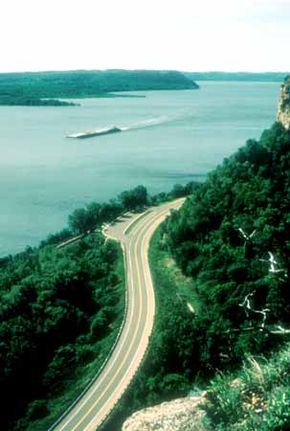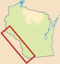
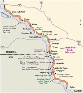
Wisconsin's Great River Road flanks the majestic and magnificent Mississippi River as it winds its way along 250 miles of Wisconsin's western border. The road is nestled between the river on one side and towering bluffs on the other.
Most of the time, the road parallels the river, but when the road does meander a short way from the river, it treats its guests to vistas of rolling farmland, as well as beautiful forested valleys and coulees.
Advertisement
Archaeological Qualities of the Great River Road
Nearly 12,000 years ago, Wisconsin was inhabited by people who hunted prehistoric animals such as mammoths and mastodons. The primitive cultures of the corridor left many artifacts and monuments to the past -- not the least of which were the great mounds of grand designs and animal shapes.
Today, Wisconsin archaeologists research these ancient cultures, as well as the cultures of the first explorers and traders who came to settle along the Wisconsin Great River Road.
The Wisconsin Great River Road runs through an area called the Driftless Area because it was not covered by glaciers during the last ice age. Because of this, many exposed rocks gave ancient inhabitants of the area an opportunity to create rock art that is still being discovered today. In caves and outcroppings, petroglyphs and pictographs have been found that depict an ancient way of life.
Archaeological displays can be found in many local museums. You can view mound groups and village sites at Wyalusing State Park, Diamond Bluff, La Crosse, Prairie du Chien, along Lake Pepin, and at Trempealeau in Perrot State Park.
In the city of La Crosse, archaeological enthusiasts can view displays at the Riverside Museum that catalog the earliest times in Wisconsin to the present. As the headquarters for the Mississippi Valley Archaeology Center, the University of Wisconsin-La Crosse Archaeology Center offers an opportunity to view displays explaining techniques and prehistory.
There are 33 archaeological sites along the corridor that are listed in the National Register of Historic Places. Excavations of these sites have revealed pottery, ceramics, arrowheads, and tools, while burial mounds are prevalent throughout the corridor.
In Onalaska, an entire prehistoric village was uncovered, revealing structures and artifacts that indicated the lifestyle of the earliest inhabitants of the area. At Trempealeau in Perrot State Park, you'll find remaining ancient mounds in the shapes of animals.
Cultural Qualities of the Great River Road
The varied past and present cultures of the corridor are recorded and revealed in the 33 river towns, the many state historical markers, and the archaeological sites found along the Great River Road.
The residents of the corridor take pride in preserving their heritage, as evidenced by the many festivals. Some of these festivals include La Crosse's Riverfest and Octoberfest, Villa Louis's Carriage Classic, Prairie du Chien's Fur Trade Rendezvous, Alma's Mark Twain Days, and Pepin's Laura Ingalls Wilder Days.
Well-maintained early homes and storefronts are evident throughout the corridor as well. Architecture from the 19th and 20th centuries is scattered throughout the towns and cities of the byway; many of them reflect the varied architectural trends of the early days of settlement. As you watch for unique architecture, you will also want to notice the mail-order houses that were constructed in a matter of days after arriving by train.
Today, unique buildings and art forms continue to surface on the Great River Road. At Prairie Moon Sculpture Garden in Cochrane, for example, a unique form of art typical to the Midwest is displayed.
Historical Qualities of the Great River Road
American Indians were the first people to live in this region, as evidenced by artifacts from archaeological sites and the presence of burial mounds. Thousands of mounds can be found throughout the area that display the culture of the Hopewell Indians who once lived here.
The culture of this people evolved over the years, and they began to establish large, permanent villages. Known as the Oneota people, they were able to farm the river valley using hoes made from bison shoulder blades. By the time the first Europeans arrived, this culture had disappeared, replaced by a group of Sioux.
French missionary Jacques Marquette and explorer Louis Jolliet were the first Europeans to come through the area. They were searching for a waterway that would connect the Atlantic Ocean and the Gulf of Mexico.
Later, French forts were established, and commerce and trade between the European and native cultures ensued. The area changed hands from the American Indians to the French to the British and finally to the Americans, but not without struggle.
From the beginning, Native Americans fought to retain their ancestral lands, but to no avail. Settlement began in Wisconsin soon after the Black Hawk War between the Sauk Indians and American troops. In 1848, Wisconsin became a state.
Wisconsin thrived as a state for lumbering and sawmills. Because the Mississippi flows alongside it, Wisconsin was in a good position for the steamboat industry to develop. Steamboat races and wrecks were as legendary then as they are today.
Remnants of the new Mississippi culture can be seen along the Great River Road: Abandoned quarries and old building ruins are just some of the things you may spot that remind you of an earlier day.
Natural Qualities of the Great River Road
Many natural wonders are found along this byway. For example, the Mississippi River/Wisconsin Great River Road corridor incorporates some national features, including the Upper Mississippi River National Wildlife and Fish Refuge, the Trempealeau National Wildlife Refuge, and the Genoa National Fish Hatchery.
There are also 12 state-recognized natural areas featuring state parks and wildlife areas, as well as many state-designated scientific areas located along the corridor.
Recreational Qualities of the Great River Road
Every season offers spectacular recreational opportunities on the Upper Mississippi River along the Wisconsin Great River Road. The Upper Mississippi provides excellent boating and sailing, and there are more than 50 local parks, beaches, recreational areas, and water access sites along the route.
On Lake Pepin, a huge lake in the Mississippi River, boaters have access to numerous boat landings, marinas, and docking. Fishing is a favorite activity because of the variety of fish species, ranging from catfish to walleye. The sandbars along the river provide places for public camping, picnicking, or just getting off the road.
Bird-watchers enjoy seeing bald eagles as the magnificent birds catch their dinners. Berry-picking and mushroom-hunting are also popular activities, and many travelers choose to experience a farm vacation by milking a cow. Shopping and antique hunting in quaint river towns may be of interest to shoppers, while golfers will find enticing, scenic golf courses.
The Wisconsin Great River Road provides safe accommodations for bikers -- with alternate choices of separate bike trails and local roads or streets. Depending on the cyclist's preference and skills, the rider has a choice of touring the Great River Road on-road or off-road. Canoe and bike rentals are available so that every visitor may enjoy these forms of recreation.
Winter in Wisconsin provides ice fishing and wind sailing on the river. Many travelers prefer cross-country or downhill skiing, snowshoeing, and snowmobiling through deep valleys and scenic bluffs. Summertime is excellent for dinner cruises on the river, or you can rent a houseboat and explore on your own. The river valley features hiking and biking trails, picnic areas, and camping opportunities in the numerous parks and campgrounds along the byway.
Find more useful information related to Wisconsin's Great River Road:
- How to Drive Economically: Fuel economy is a major concern when you're on a driving trip. Learn how to get better gas mileage.
Advertisement