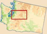
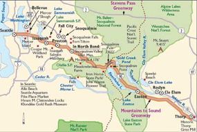
Moutains to Sound Greenway (Interstate 90) is the primary east/west highway in Washington. It begins at the historic Seattle waterfront and travels east over the Cascade Mountains to the dry plateaus of eastern Washington.
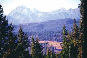
As you travel east along this 100-mile byway, you experience lush green forests, the marine beauty of Puget Sound, pastoral valleys, and a dramatic mountain landscape. You also pass through a complete change in climate, geology, and hometown style.
Advertisement
Each year, more than 20 million vehicles travel this route, making I-90 a popular gateway between Washington's largest city and its diverse and striking landscapes.
Historical Qualities of Mountains to Sound Greenway
The byway's historic sites demonstrate different eras of modern history. Some sites possess the soul of the Old West, some seem to still embrace the spirit of early industry, and some retain the more obvious past of the last few decades.
The soul of the Old West is possessed in locations such as Fort Tilton, the site of an 1850s fort (also a wildlife wetland), and Meadowbrook Farm, a historic landscape in the dramatic shadow of towering Mount Si.
Meadowbrook Farm was the site of a Native American village that became the world's largest hop ranch at the turn of the 19th century. The Klondike Gold Rush Museum, located in the historic Pioneer Square district, houses photos and memorabilia from Seattle's turn-of-the-19th-century boom days.
And what would the Old West be without a few mining operations? Catch a glimpse of a 19th-century coal-mining town at Roslyn. The town hasn't changed much in all these years, except for sprucing up the main street for the 1990s TV series Northern Exposure. Roslyn also has a museum with photos, mining tools, and historical information; the historic graveyard is divided into ethnic zones reflecting the many nations that sent miners here.
The spirit of early industry is still embraced in places such
as Preston, a turn-of-the-19th-century Scandinavian mill town. Presently, Preston consists of the remnants of a small northwoods logging town along a river, including a number of historic homes and the church.
The Historic Thorp Grist Mill, built in 1883, is the oldest industrial artifact in Kittias County. The mill houses a remarkable collection of handmade wooden mill machinery and is open to the public.
In addition, Fall City Waterfront was the final upstream landing for early steamboats on the Snoqualmie River, Reinig Road Sycamore Corridor was the tree-lined main street of a former company town, and Mill Pond was the Snoqualmie Mill's former log-holding pond (and is now home to a variety of fish and wildlife).
Natural Qualities of Mountains to Sound Greenway
The western flanks of the Cascade Mountains, through which the greenway passes, are some of the best conifer treegrowing lands in the world. The combination of temperate climate and ample rainfall produces record growth of Douglas fir, western red cedar, and western hemlock.
Lumbering was Washington state's first industry, and trees from this region helped build San Francisco and many other 19th-century cities. You can still find remnants of the massive trees that once grew here.
Spend an hour in a beautiful old-growth forest just a mile from the interstate at exit 47 on the Asahel Curtis Nature Trail. Named for a naturalist, photographer, conservation leader, and a founder of the Mountaineers, the Asahel Curtis Nature Trail provides an excellent glimpse of the ancient forest that once existed. You are surrounded by towering oldgrowth cedar, pine, and fir trees, as well as underbrush that range from devil's club to Canadian dogwood. The atmosphere is completed by rustling streams crossed by log bridges.
Recreational Qualities of Mountains to Sound Greenway
Thousands of miles of recreational trails head from the byway. Most of these trails support hiking, but some of the trails are also great for biking and horseback riding. These trails range in length and difficulty. Some are great for day trips, and others take you deep into the backcountry.
Walkers and bicyclists can begin a journey into the mountains from the heart of Seattle on the separated I-90 trail that has its own tunnel and crosses the scenic Lake Washington floating bridge. A series of regional trails lead to the John Wayne Pioneer Trail just south of North Bend (about 40 miles from Seattle). This converted rail/trail crosses the mountains on a wide and gentle slope and includes a two-mile tunnel under the Snoqualmie Summit on its way to the Columbia River.
Another of the more frequented hiking areas is the Burke Gilman Trail, which begins in Seattle and goes to the suburban towns of Bothell, Woodinville, and Redmond and passes farmland before arriving at Marymoore Park in the shadow of the Microsoft campus.
At the Snoqualmie Summit, exit 52, you can gain access to the Pacific Crest Trail that runs from Mexico to Canada. By taking the trail northward from this exit, you enter the Alpine Lakes Wilderness Area and spectacular high alpine country, dotted with hundreds of small lakes and profuse displays of wildflowers.
Another popular hiking area is in the Cougar Mountain Regional Wildland Park, the largest wild park in an urban area in America at 4,000 acres. This network through wetland and forest passes 19th-century coal-mining shafts and concrete foundations.
Another park, the Squak Mountain State Park, offers excellent hiking because its 2,000 wooded acres are a first-rate wildlife habitat.
The Tiger Mountain State Forest has the state's most heavily used trails. This web of trails for hikers, mountain bikers, and equestrians winds through 13,000 acres of working forest and conservation area. The two access points are just minutes from Seattle suburbs.
At 4,190 feet, Mount Si towers over the town of North Bend and is a favorite hiking destination with its strenuous eight-mile round-trip trail to the summit or its five-mile round-trip trail to Little Si.
Also, the Rattlesnake Ledge Trail climbs steeply (1,175 feet in 1 mile) from Rattlesnake Lake through classic western Washington forests to rock outcrops that provide sweeping views of the Central Cascades and Snoqualmie Valley.
The Middle Fork Snoqualmie River Valley, on the edge of the Alpine Lakes Wilderness, has a variety of trails that wind among more than 100,000 acres of both ancient and recently harvested forests. The valley is minutes from North Bend but is lightly visited. An unpaved 12-mile road leads to a footbridge, the access to many miles of backcountry trails.
Other great places to hike around this byway are Twin Falls State Park, the Asahel Curtis/Annette Lake Trail, the trail to Denny Creek and Franklin Falls, Snoqualmie Pass Summit, the John Wayne/Iron Horse Trail and Snoqualmie Tunnel, and the Coal Mines Trail.
Find more useful information related to Washington's Mountains to Sound Greenway:
- Washington State Scenic Drives: Mountain to Sound Greenway is just one of the scenic byways in Washington. Check out the others.
- How to Drive Economically: Fuel economy is a major concern when you're on a driving trip. Learn how to get better gas mileage.
Advertisement