Hawaii Scenic Drive: Kamehameha Highway

By: Clark Norton  | 
A highway surrounded by beautiful, natural scenery in Hawaii.
Get away from the hustle and bustle of the big city and take a trip down the scenic route of the Kamehameha highway. John Seaton Callahan / Getty Images

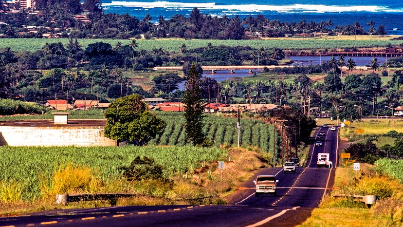
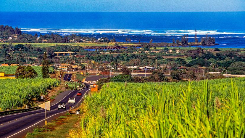
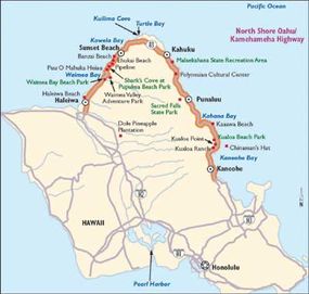
Away from the urban bustle of Honolulu and the crowds of Waikiki, the Kamehameha Highway (Route 83), the road that traverses the North Shore of Oahu, is a study in pastoral tranquility and rural charm. It's set against the backdrop of the blue Pacific.

The Kamehameha Highway -- named for King Kamehameha the Great, who conquered and unified all the Hawaiian islands in the late 18th and early 19th centuries -- hugs the Pacific Ocean from the eastern (windward) side of the island going north and then west until it dips south toward Pearl Harbor at the town of Haleiwa.

Advertisement

Along the way, it passes a succession of small coves and bays and miles of white-sand beaches, some nearly deserted. In summer, the ocean waters tend to be fairly calm and good for swimming. In winter, the waves at Waimea Bay and Sunset Beach may hit 25 to 30 feet or more -- the largest surfable waves in the world.

Those who travel Oahu's unspoiled North Shore will soon feel as though they have escaped to the Hawaii of old. Roadside vendors peddle local delicacies such as coconuts, fresh pineapple (the Dole Plantation is farther down Kamehameha Highway to the south), Kahuku sweet corn, and cold shrimp.

General stores and food stands offer up some of the islands' most refreshing shaved ice, the exceptionally tasty Hawaiian version of the snow cone; tropical flavors include pineapple, coconut, and passion fruit, and are often served over ice cream or azuki beans. The historic resort town of Haleiwa, the "surf capital of the world," features old-fashioned eateries, intriguing shops, and, of course, the ever-inviting Pacific surf.

As beautiful as the drive is, it's hard to resist stopping at one

of the many beaches along the North Shore. Sunset Beach, Ehukai Beach, and Waimea Bay are world famous for their monster waves and surfing competitions. Malaekahana State Recreation Area has terrific swimming and body surfing. Other beaches, such as Shark's Cove at Pupukea Beach Park, are known for their tide pools and snorkeling.

Kawela Bay and Kuilima Cove are uncrowded sandy beaches with safe swimming and snorkeling year-round. In winter, beachgoers might spot humpback whales offshore, migrating south from Alaska to mate.

This map will help guide you along the Kamehameha Highway.

For more information related to Hawaii's Kamehameha Highway, see:

  • Hawaii Volcanoes National Park, Haleakala National Park: Find out about visiting these awesome national parks in Hawaii.
  • How to Drive Economically: Fuel economy is a major concern when you're on a driving trip. Learn how to get better gas mileage.

Advertisement

Highlights of the Kamehameha Highway

kamehameha highway
USA, Hawaii, Oahu, North Shore, Kamehameha Highway John Seaton Callahan / Getty Images

For those who approach from the windward (eastern) side of Oahu, the scenic drive along Hawaii's Kamehameha Highway begins at Kualoa Point, at the northern end of Kaneohe Bay, which overlooks the conical-shaped island known as Chinaman's Hat and is the site of Kualoa Beach Park. (Those who approach from the leeward or western side, almost due north from Pearl Harbor, will begin the drive at Haleiwa, so simply reverse the order given here.)

Kualoa Ranch: Kualoa Ranch, a 4,000-acre working ranch just beyond Kualoa Beach Park, has both seafront and a backdrop of steep green mountain cliffs. It offers horseback riding, ranch tours, and other outdoor activities.

Advertisement

Sacred Falls State Park: The highway continues north directly along the windward shore, past Kaaawa Beach, Kahana Bay, and the small resort area of Punaluu. Just beyond Punaluu Beach is Sacred Falls State Park, where a two-mile hiking trail leads through a canyon to the falls, considered Oahu's most beautiful. The trail was closed in 1999, however, due to dangerous rockslides. Check at the entrance for current status.

Polynesian Cultural Center: A bit farther north up the coast in Laie is the Polynesian Cultural Center, said to be Hawaii's most popular paid attraction, which depicts life in Pacific island cultures from Hawaii to Fiji and the Marquesas. Evening luaus and other entertainment are also offered.

Kahuku: Near the northernmost point on the island (Kahuku Point) is the historic sugar plantation town of Kahuku, site of an old sugar mill.

Turtle Bay: As the road dips southwest, an isolated promontory leads to Turtle Bay, surrounded by two protected swimming coves, Kawela Bay and Kuilima Cove. Besides miles of isolated beaches, Turtle Bay is known for winter whale watching and the North Shore's major resort hotel.

Sunset Beach: A bit farther west comes a quick succession of world-famous surfing beaches -- Sunset Beach, Ehukai Beach, Pipeline, and Banzai Beach -- where waves are most powerful in winter. These present the best views of what's called the Banzai Pipeline, where surfers disappear inside the tube-shaped barrel of a "perfect wave" and emerge seconds later when it breaks. (Banzai, a Japanese war cry, refers to the courage to surf there.) Professional surfing competitions are held on these beaches in winter. Just down the road is Pupukea Beach Park, known for its tide pools, snorkeling, and diving.

Puu O Mahuka Heiau: Across from Waimea Bay, take a left turn down Pupukea Road to the Puu O Mahuka Heiau -- Oahu's largest heiau (sacred temple) -- an 18th-century historic landmark perched on a ridge with a spectacular view of Waimea Valley.

Waimea Valley Adventure Park: The next left off the highway, Waimea Valley Road, leads to the 1,800-acre Waimea Valley Adventure Park, which has a botanical garden with thousands of species of tropical plants, a 45-foot waterfall, cliff divers, hula demonstrations, a kids' area, and more.

Waimea Bay Beach Park: Back on Kamehameha Highway, the surf's up again at Waimea Bay Beach Park, where the waves may reach 30 feet or higher in the winter months. In summer, you can swim in calm turquoise waters.

Haleiwa: At the end of this North Shore drive is Haleiwa, established in 1832 on Waialua Bay by Protestant missionaries. The missionaries' original church and the remains of their adobe home still stand, and much of the town has a rustic, early 1900s feel, complete with paniolo (Hawaiian cowboy) architecture. Old general stores coexist with modern boutiques, art galleries, eateries, and the North Shore's largest marina.

Get a taste of the Hawaii that once was, as well as access to some of the world's top surfing beaches, by traveling along the Kamehameha Highway.

For more information related to Hawaii's Kamehameha Highway, see:

  • Haleiwa, Oahu: Find out what there is to do in Haleiwa and other cities along Oahu's Kamehameha Highway.
  • Hawaii Volcanoes National Park, Haleakala National Park: Find out about visiting these awesome national parks in Hawaii.
  • Scenic Drives: Are you interested in scenic drives beyond Hawaii? Here are more than 100 scenic drives throughout the United States.
  • How to Drive Economically: Fuel economy is a major concern when you're on a driving trip. Learn how to get better gas mileage.

Advertisement

Advertisement

Loading...