Top 10 New England Leaf-peeping Locales

By: Maria Trimarchi
Autumn foliage in Winchendon, Mass. See more pictures of trees.
Stan Honda/AFP/Getty Images
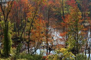
Maybe it's the apple cider and pumpk­ins, kids back in school or the first sweater of the s­ea­son, but as­ soon as the crisp autumn a­ir hits us, we turn into leaf-peepers. October is perfect for meandering through New Engl­and's small towns and back roads on a leaf hunt.

Remember to ­bring plenty of snacks and a camera. Since rest stops can be few and far between on these roads, be good to yourself and your travel buddies: Even if you don't have to go, at least try.

Advertisement

­In this article, we visit 10 scenic routes for leaf peeping across New England state-by-state. Grab a map, fuel up the car and let's find some foliage!

­

10. Route 100, Vermont

Begin your drive heading north from Stamford and enjoy the ride. While the foliage is the main focus, you'll also pass sugar houses and general stores. Stop in Wilmington for a snack and a walk around the main street. Then head north past a few ski areas to Weston, home to the Vermont Country Store.

Continue north to Granville and stop at Moss Glen Falls. Of all the falls in Vermont, this is one of the easiest to reach, so grab the camera and head to the boardwalk. Driving further north, you'll have your fill of galleries, inns and of course foliage. Plus, there's a covered bridge just up from the intersection of Routes 100 and 17.

Advertisement

Finally, end in Waterbury Center, where you'll find Cold Hollow Cider Mill and their famous cider donuts.

Find your way: Route 100 is a long but relaxing drive through the Green Mountains, from the border of Massachusetts to nearly Canada.


9. Grab a Map and Drive, Vermont

In Southern Vermont, give Route 7A a try, with a jaunt on Equinox Skyline Drive south of Manchester. Detour onto Route 67 and discover Old Bennington -- don't miss Robert Frost's grave at the Old Bennington Cemetery -- and Hathaway's Drive-in Movie Theater. Alternatively, Route 7 intersects with Route 9, where heading west will take you through scenic Willmington and into Brattleboro.

If you find yourself in Northern Vermont, try Route 108. You won't want to miss the Trapp Family Lodge in Stowe, Stowe Village and Smuggler's Notch State Park.

Advertisement

Find your way: Vermonters will tell you they have the best foliage in New England -- they might tell you they have the best foliage, period. You can't go wrong behind the wheel with a whole day ahead of you. If you're known for your lack of orientation skills, be sure you have a map or navigation system.


8. Dartmouth-Lake Sunapee Region, New Hampshire

Route 12A meanders along the Connecticut River and is known for its old barns and covered bridges. The Cornish-Windsor covered bridge -- the longest two-span covered bridge in the United States -- is in this region (don't miss its sign: "Walk your horses or pay two dollars fine").

From Route 12A, pick up Route 11 and head east to scenic Sunapee Lake. Or, take a ride to the top of Mount Kearsarge at Rollins State Park in Warner. From the summit, you can see Boston, the Green Mountains of Vermont and east to the Atlantic Ocean.

Advertisement

Find your way: Plan your trip to begin on Route 12A in Claremont, but be open to exploring the region. This drive is better suited for those with wanderlust and time to explore.

7. Kancamagus Scenic Highway, New Hampshire

This is a mountainous route that rises to nearly 3,000 feet as you drive, but your reward for navigating the steep drive is plenty of photo opportunities, alpine and valley panoramas, covered bridges, and waterfalls.

Along the way, stop at the Rocky Gorge scenic area and walk over the footbridge to Falls Pond.

Advertisement

If you want to stretch your legs with a day hike, check out Greeley Ponds and Sawyer Ponds, or take an easy walk along the Sabbaday Brook Trail to see the Sabbaday Falls.

Find your way: Route 112 runs through the White Mountains. Begin in Conway and end in Lincoln, stretching from the Saco River to the Pemigewasset River.

6. Acadia National Park Loop Road, Maine

Acadia National Park Loop Road is about 27 miles long and offers something for everyone: mountains, forests and ocean. Begin at the Hulls Cove Visitor Center and plan to stop at Sand Beach, Thunder Hole and Otter Cliffs to take in the views. In the heart of the park is the Sieur de Monts Spring, where you'll want to visit the Abbe Museum and the Wild Gardens of Acadia.

If you'd like magnificent views, including the Porcupine Islands and Frenchman Bay, take the 3.5 mile drive up Cadillac Mountain. Be careful, as the road up this granite mountain is narrow and winding with steep rises.

Advertisement

Find your way: Follow Route 3 around Acadia National Park on Mount Desert Island.

5. Stick to Route 1, Maine

The outlet stores in Kittery can mean clogged roads, but be patient and head north for low-lying sea marshes and foliage-covered hills. Follow Route 1 from one historic town to the next, from York, Ogunquit, Wells and into Kennebunk. Want to wander from your route? Take a detour onto Route 52 to see Megunticook Lake -- and don't miss Maiden Cliff.

Find your way: This route will take you along the southern Maine seacoast. Start out on Route 1 in Bath and follow Route 1 or Route 1A to Kennebunk. This can take you to our next stop, Acadia National Park Loop Road, if you want to expand your trip.

Advertisement

4. Blackstone River Valley, Rhode Island

Close your eyes and think of a country road with farms and apple orchards. Although this route requires you to take your eyes from the scenery to follow your map, the Glocester Loop through the Blackstone River Valley takes you along roads that rival those in your imagination, filled with historic homes and mills (Blackstone River Valley is the birthplace of America's Industrial Revolution). Don't miss the Great Road Historic District in Lincoln, where you'll feel you've gone back to the early nineteenth century.

Find your way: The Glocester Loop takes you on a loop beginning and ending on I-295. Take Exit 7 off I-295 and travel west on Route 44. Pass through the town of Chepachet and continue to the village of West Glocester. Once there, turn onto Route 94 S and continue your drive through North Foster. Route 94 ends at its intersection with Route 14, where you will turn left. Take Route 14 through Scituate. Turn left onto Route 116 and travel north. At Route 44 turn right and return to I-295.

Advertisement

3. Historic Route 169, Connecticut

While picturesque, this route is best for the history buff. Bring along passengers who also enjoy exploring historical sites.

Stop in Canterbury for a visit to the Prudence Crandall Museum. Continue on to Brooklyn for a stop at the Brooklyn Green, a site on the National Register of Historic Places. Next, don't miss the Friendship Valley Inn, a stop on the Underground Railroad.

Advertisement

Take a recess from the history lesson in Pomfret with a visit to the Lapsley Orchard for apple picking, and end your break at the Sharpe Hill Vineyard and Winery. Once you make it to Woodstock, don't miss the Roseland Cottage (also known as the Pink House).

Find your way: Our route runs through the "Quiet Corner" of rural northeastern Connecticut. Begin on Route 169 in Lisbon and continue toward Woodstock.

2. Old King's Highway, Massachusetts

The Old Ki­ng's Highway is flush with historical sites, antique stores and art galleries. It's a narrow road that wraps you up in its foliage and historical homes -- don't miss Edward Gorey's preserved home on Strawberry Lane -- together with a view of the Cape Cod bay. Depending on the weather and the season, you may catch the cranberry harvest. You can't go wrong with the seafood, either, but beware that many restaurants (and some shops) close after the summer tourist season ends around Labor Day.

Find your way: Old King's Highway is Route 6a on Cape Cod. It winds from the Sagamore Bridge over the Cape Cod Canal and through the towns of Sandwich, Barnstable, Yarmouth Port, Dennis, Brewster and Orleans.

Advertisement

1. Mohawk Trail, Massachusetts

This is a curvy and mountainous route, and near the beginning of the trip, you'll be negotiating the Hairpin Turn, by far as bad as it sounds. There are plenty of parking spots where you can pull over and enjoy the first scenic vista -- a view of Mount Greylock, the Green Mountains and Hoosac Valley.

Continuing on the Mohawk Trail, be sure to stop to check out the views from the Western Summit, then through the town of Florida to the Whitcomb Summit. Another must-see is the Hail to the Sunrise statue, a Mohawk Indian looking to the east with arms uplifted to the Great Spirit.

Finally, don't miss the town of Shelburne Falls for its quaint main street, famous Bridge of Flowers and glacial potholes at Salmon Falls.

Find your way: Pick up Route 2 in North Adams and continue on it until Greenfield (although Route 2 will take you all the way to Boston if you're so inclined).

Lots More Information

Relate­d HowStuffworks Articles

­

Advertisement

Loading...