Iowa Scenic Drive: Great River Road

By: Melissa Arnold
This map will help guide you along the Iowa Great River Road.

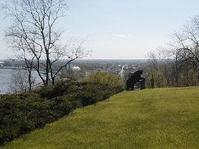
Join travelers from around the world to discover dramatic vistas of Old Man River during all seasons. This scenic drive offers beautiful landscapes and views of soaring eagles and 100,000 migrating geese and ducks.

Experience Midwest hospitality on the main streets of river towns and cities, or visit sacred sites and landscape effigies of Native Americans. You can also experience the Mississippi River on steamboats, commercial barges, and recreational crafts.

Advertisement

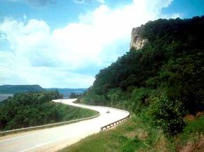
The byway's story begins with the landscape: abrupt and dramatic limestone bluffs cut by glacial meltwater in the north contrast with broad sandy floodplains in the south. For thousands of years, Native Americans knew the importance of the continent's largest river.

Later, its meandering course marked the political boundaries of territories, towns, cities, states, and counties of the advancing society. Today, the Upper Mississippi River and the Great River Road are national repositories of geological wonders, unparalleled scenic beauty, wildlife, native vegetation, and the miracles of hydrology. The river and road are also milestones to the expansion and development of the United States and the Midwest.

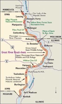
The Great River Road stretches into Illinois, Wisconsin, and Minnesota. Keep reading to find out about the sights you'll see on the Iowa leg of this scenic byway.

Find out more useful information related to the Great River Road:

  • Loess Hills Scenic Byway: On the western border of Iowa, the ecologically unqiue Loess Hills offer great scenery. Learn where to drive through it.

Advertisement

Highlights of the Great River Road

This map will help guide you along the Iowa portion of the Great River Road.

Not sure where to begin? Consider taking this Lansing to Guttenberg tour of Iowa's Great River Road.

Lansing: The tour begins in Lansing, home of Mount Hosmer Park. Also of interest is the Fish Farm Mound (an Indian burial site) and the nearby Our Lady of the Wayside Shrine.

Advertisement

Harpers Ferry: The next stop, Harpers Ferry, is 15 miles past Lansing. The town is built on a concentrated area of Native American mounds and was an important river town after the introduction of the steamboat. The Mississippi backwaters behind the town still attract hunters, trappers, and commercial fishing.

Yellow River Forest State Recreation Area: Just south of Harpers Ferry lies the Yellow River Forest State Recreation Area. This 8,000-acre forest contains some of Iowa's greatest terrain, with high scenic bluffs and cold streams. The Iowa Department of Natural Resources harvests the Yellow River Forest timber for use all over the state. The Paint Creek unit of the forest houses most recreational opportunities, including camping, canoeing, snowmobiling, hunting and fishing, and hiking trails.

Effigy Mounds National Monument: Effigy Mounds National Monument, the next stop, is just two miles south of Yellow River Forest. Prehistoric mounds are common from the plains of the Midwest to the Atlantic seaboard, but only in this area were some of them constructed in an effigy outline of mammals, birds, or reptiles. Eastern Woodland Indian cultures built these mounds from about 500 B.C. to A.D. 1300. Natural features in the monument include forests, tallgrass prairies, wetlands, and rivers.

© View from bluff overlooking Lansing, Iowa and the Iowa Great River Road.

Marquette: The Effigy Mounds National Monument Visitor Center, located in Marquette, includes displays of local Woodland and Mississippian cultures, artifacts, and a herbarium. Riverboat casino gambling is available on the Miss Marquette Riverboat Casino.

Pikes Peak State Park: Pikes Peak State Park is five miles south of Marquette. This park boasts one of Iowa's most spectacular views across the Mississippi on the highest bluff along the river. It was named for Zebulon Pike, who was sent in 1805 to scout placement of military posts along the river. A fort was never built on this land, and it went into private ownership. Because settlers were not able to build on this property, the peak remains as Zebulon Pike saw it 200 years ago.

Guttenberg: The tour terminates in Guttenberg, 15 miles south of Pikes Peak State Park. Guttenberg boasts two scenic overlooks and a mile-long landscaped park along the river. A copy of the Gutenberg Bible is on display at the local newspaper. The city offers blocks and blocks of historic buildings.

Find out more useful information related to the Great River Road:

  • Loess Hills Scenic Byway: On the western border of Iowa, the ecologically unqiue Loess Hills offer great scenery. Learn where to drive through it.

Advertisement

Things To Do Along the Great River Road

Iowa Division of Tourism Morning view over Lock and Dam 11 and the Mississippi River from Eagle Point Park, Dubuque, Iowa.

Geology, the hydrologic cycle, and erosion are among the big stories that the Mississippi River and the Great River Road tell in Iowa. The forces of nature can be seen in how the river has cut a deep channel in ancient limestone layers in the northern reaches. The ever-changing channel of the river, the deposition of sediments, and the broad floodplain of the Mississippi River in the southern part of the state speak of a different natural dynamic. The Upper Mississippi River National Wildlife and Fish Refuge is the state's oldest and most popular wildlife refuge. Many other state, county, and city parks provide opportunities for spotting and watching wildlife.

Recreational Qualities of the Great River Road

Recreational opportunities abound along the Iowa Great River Road. Water activities include boating, sailing, fishing, waterfowl hunting, and swimming. For decades, the Iowa Great River Road and its side roads have been popular pleasure routes for sightseeing. Numerous multipurpose trails and support facilities are available along the road.

Advertisement

Scenic Qualities of the Great River Road

The magnificent scenery of the Great River Road is centered around the Mississippi River. The river is almost continuously visible from the Great River Road (or is within a few miles of the byway). Dams along the river create large pools of open water upstream. Along the northern part of the river, steep limestone bluffs descend directly to the banks. Downstream, the floodplain opens to afford long, uninterrupted views of the valley. Roadside spots, shady parks, and locks and dams of the Mississippi River offer places for you to stop and take in the scenic beauty of the Great River Road and the Mississippi River.

The four seasons provide dynamic backgrounds and changes in the vegetation and activity on the water. The rural landscape provides a multitude of settings for small farms, protected wetlands, streams and rivers, and woodlots and forests. The residential and main street architecture of small towns and river cities offers much interest and contrast to the rural images. Many efforts exist to protect the countryside landscape character.

The next section will detail some of the historical sights you'll see as you pass along the Iowa stretch of the Great River Road.

Find out more useful information related to the Great River Road:

  • Loess Hills Scenic Byway: On the western border of Iowa, the ecologically unqiue Loess Hills offer great scenery. Learn where to drive through it.

Advertisement

History of the Great River Road

Although most of Iowa was settled in the mid-1800s, the Mississippi River made it an accessible territory long before the United States became a nation. Native Americans and explorers alike saw the raw, unharnessed power of this beautiful passageway. One of the first outposts was Fort Madison, where history is recreated today. Like much of the United States, the Great River Road was under Spanish and French rule until the time of the Louisiana Purchase in 1803.

Soon after, settlers and industry came to Iowa. Bustling river towns created cultural landmarks such as Snake Alley -- the curviest road in the United States. Little towns along the road grew and became the cities they are today. During the booming days of river trade, writer Samuel Langhorne Clemens (better known as Mark Twain) captured the atmosphere and the time period in his novels. When the Civil War came to Iowa, most of the people living there fought for the Union. Civil War memorials are now found in several of the towns on the byway.

Advertisement

Archeological Qualities of the Great River Road

A primary site on the Great River Road is the Effigy Mounds National Monument, the site of 195 mounds. Of these 195 mounds, 31 are effigy outlines of mammals, birds, or reptiles. Eastern Woodland Indian culture built these sites between 500 B.C. and A.D. 1300. They are preserved and interpreted for the public. Additional property was being added to the monument site to expand its protection of these unique resources. Other important sites are found at the Mines of Spain State Recreation Area and the Toolesboro Indian Mounds National Historic Landmark.

Iowa's portion of the Great River Road offers a variety of historical sights, recreation areas, and charming towns to visit along your way.

Find out more useful information related to the Great River Road:

  • Iowa Scenic Drives: The Loess Hill Scenic Byway is one of many scenic drives in Iowa. Check out all the Iowa Scenic Drives.
  • Loess Hills Scenic Byway: On the western border of Iowa, the ecologically unqiue Loess Hills offer great scenery. Learn where to drive through it.

Advertisement

Advertisement

Loading...