A Guide to Hiking the Santa Rosa Mountains

By: Jacob Clifton
While hiking through the desert, Dave and Cody find that high winds, massive amounts of dust and heat don't mix too well.
Discovery

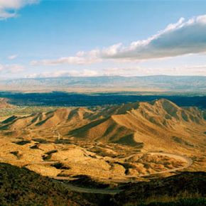
For most of us, the Palm Springs desert signifies a very specific, pretty intense image of hard-dealing moguls, aging starlets, impossibly expensive and well-kept golf courses, crazy castles, and other high-end real estate. But Riverside and San Diego counties also play host to some of the most diverse climatic and ecology zones in the country. Sometimes mountainous, sometimes desert, nestled between the Coachella and Colorado River Valleys, and between La Quinta to the north and Anza Borrego Desert State Park to the south, you can find some of the most beautiful and challenging terrain -- often, just minutes from the cities and suburbs.

Within the National Monument region -- which contains both the Santa Rosa Wilderness and the San Jacinto area northward -- the California Bureau of Land Management considers the Santa Rosas everything east of Palm Canyon, as the terrain moves from mountain to desert. The Northern range lies between that Palm Canyon divide and Highway 74, while the southern range runs from Highway 74 to the Anza-Borrego Desert State Park [source: Oh, Ranger].

Advertisement

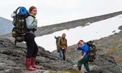
Established by Congress as a protected Wilderness Area in 1984, Santa Rosa is a 72,259-acre (29,242-hectare) area of the Santa Rosa Mountains located mostly in the Santa Rosa and San Jacinto Mountains National Monument [sources: Wilderness.net, Oh, Ranger]. There are no paved roads, and the trails can be confusing when you're on them due to lack of landmarks, so it's important to stick to established paths and follow your map. As with any hiking expedition, it's best to turn back or take a loop once you've expended half your water. It's a desert, which means there's going to be a lot of sun, but you'll need to bring layers for longer hikes as well, as the weather can change quickly.

The best time of year for lower elevation trails is November through April; the more challenging higher trails are best explored in May through October. Cross-country travel and camping in Peninsular bighorn sheep habitat is only allowed from October to December. In this article, we'll talk about the specifics of the range -- its flora, fauna and history, as well as particular trails considered local favorites. But before hiking, remember to check with the National Monument Visitor Center for any alerts [source: USDA].

Advertisement

Interesting Features of the Wilderness

The Santa Rosa range, its peaks and canyons, were all formed by igneous and metamorphic rock moving between two major tectonic zones, the San Andreas and San Jacinto Faults. Spring-fed streams run through the steep canyons and support fan palm oases that sometimes appear seemingly out of nowhere. Part of the Peninsular Ranges that connect Southern California to Baja, the range and faults all trend northwest-southeast, meaning you're heading inland the further south you travel.

The native rare plants of the wilderness in this area are incredibly diverse and fascinatingly named, from Nuttall's scrub oak to the triple-ribbed milkvetch, beavertail cactus, fishhook cactus, Orcutt aster, desert woolstar, apricot mallow, and the pink-blooming cheesebush. The range is known for its wildflowers and flowering cactus, as well as brightly colored trees like the palo verdes and desert willow. If your goal is to see incredible blooming flowers, check your weather advisory: A dry summer means less flowers and perennials to enjoy, although desert mainstays such as the tall ocotillo and sturdy pinon pine, and many types of yucca and cholla cactus, are fairly reliable bloomers.

Advertisement

In terms of fauna, there are mule deer, coyote and bobcat throughout, as well as quail and dove, golden eagles, kit foxes, iguanas, chuckwallas and the red diamond rattlesnake. Several species of jackrabbit appear at dawn and dusk, as well as meat-eating roadrunners looking for lizards and snakes and mice. But most conversation -- if not sightings -- tends to focus on the Peninsular Bighorn Sheep.

The Range is a protected habitat for these endangered animals, with a stable population of only about 30 adults, with a total population of roughly 800 sheep, ranging down out of the Santa Rosas. Peninsular Bighorn Sheep tend to roam the range between a 1,000 and 4,000 feet (304 and 1219 meters) in elevation. The Bear Creek, Deep Canyon and Martinez Canyon oases are important locations in the summer for Bighorn reproduction, and you can sometimes spot sheep on the slopes, in the rocks just above the desert floor [source: Bighorn Institute].

Advertisement

Santa Rosa Mountain Hiking: Trails in the North Santa Rosas

A view of the Coachella Valley from Highway 74
©iStockphoto.com/Lawrence Freytag

The Indian Canyons mark part of the divide between Santa Rosa and San Jacinto, which is noticeable for the exposed bedrock along the fault. So-named for their rich native history, the trails date back to pre-American times, and were used by the local Cahuilla Indians to travel between the valley and mountains. Palm Canyon Trail is a strenuous 16 miles (25.7 kilometers), with various shorter loops possible via other trails, and it includes an elevation change of 3,566 feet (1,087 meters) from bottom to top [source: USDI: BLM].

It moves from the Indian Canyons trading post all the way to Highway 74, or the length of the Northern range, and reflects the whole terrain transition from the Sonoran desert to cooler forests of pinon and juniper trees, moving from oasis to oasis. Although it's still sometimes called the "Trail of a Thousand Shrines" for the native archeological discoveries that have been made there, the shrines are mostly lost now, so hikers are warned to leave special finds intact.

Advertisement

Another moderately strenuous trail, the Art Smith, is 8.3 miles (13.4 kilometers) long, with an elevation change of 1,465 feet (447 meters) [source: USDI: BLM]. Famously offering vistas of Coachella Valley and the Joshua Tree National Park, it was named for one of the leaders of the Desert Riders equestrian club, which still cares for the trail. Similar in length and elevation is the "Hoppy" -- Hopalong Cassidy Trail -- which was, of course, named for the fictional cowboy. It moves near and through more developed areas while also working its way around mountainsides in a challenging roller-coaster-like system of switchbacks. While there are plenty of connecting trails you can use to create shorter hikes, anything south of Homme-Adams Park is for experts only.

There's a complex of strenuous, but shorter, trails -- beginning with the moderate and enjoyable-on-its-own Wild Horse Trail -- that focus on Murray Hill, an iconic peak south of Palm Springs. The only way up the peak itself is via the Clara Burgess Trail, which is just 2.2 miles (3.5 kilometers) long but takes you a full 1,339 feet (408 meters) upwards, in total. Compare that to the much longer trails above, and it's clear that Clara Burgess should only be attempted by the hardiest explorers with the most time to spend on switchbacks and harsh terrain [source: USDI: BLM]. If attempting the north side of Murray Hill, be very sure you know the route. Those trails near the bottom of the peak can confuse even locals.

If you're looking for a family adventure in the North range, try the trail to Gunsight Rock. It's about 5.6 miles (9 kilometers) long, so it can take up to three hours to hike in the spring, but it's well worth the preparation and challenge. The rock features are fascinating, and on a clear day you can see all the way to the Golden Gate Bridge.

Advertisement

Santa Rosa Mountain Hiking: Trails in the South Santa Rosas

Southeast of Highway 74, you're in the Southern Santa Rosas. It's a bit more mysterious in some places, full of desert features and peaks such as the Santa Rosa and Toro peaks above Palm Desert. The Cahuilla Indians harvested acorns, yucca fibers and pinon nuts on these slopes, and they used the same trails we can walk today. Villager Peak is nearly 6,000 feet (1,828 meters) high, and on a clear day you can see as far as 100 miles (161 kilometers) from the top [source: National Geographic].

The most popular and rugged trail in the heart of the wilderness is Cactus Spring, an 11.7 mile (18.8 kilometer) trek that leads you up 2,639 feet (804 meters) through lots of different zones and terrain types. A route to Martinez Canyon can take almost 18 miles (29 kilometers), for example, while other trails can lead all the way to San Bernardino National Forest to the west [source: USDI: BLM]. The spring itself is on Sheep Mountain.

Advertisement

For a shorter journey, try the 5-mile (8-kilometer) round-trip to Horsethief Creek, which includes -- with its stunning wildflowers, beautiful cottonwoods and an abandoned dolomite mine -- a fascinating history: It's named for a band of horse-traders who would steal horses from one farm, re-brand and sell them, and then go back and do the same thing with the same horses.

Garstin Trail is a moderately difficult trail, 1.5 miles (2.4 kilometers) with an elevation change of 893 feet (272 meters), which includes connections to the Shannon, Henderson and Wild Horse Trails [source: USDI: BLM]. An easier journey for beginners is the Randall Henderson Trail, which rises only 423 feet (129 meters) over 2.4 miles (3.9 kilometers), and begins at the National Monument Visitor Center [source: USDI: BLM].

A more strenuous trek is the 8.8 miles (14.1 kilometers) of the Boo Hoff Trail, which as a 1,916-foot (584-meter) elevation change, and a rich history all its own [source: Salton Sea and the peak of San Jacinto Mountain.

Advertisement

Santa Rosa Mountain Hiking: Plateau Hikes

If you're lucky, you may get to see a red-tailed hawk in person while you're hiking the Santa Rosa plateau.
©iStockphoto.com/Steve Mollin

The Plateau is an 8300-acre (3359-hectare) reserve near Temecula is famous for its wildflowers and oasis pools [source: red tailed hawk or wily coyote.

The Hidden Valley Trail is a 6-mile (9.7-kilometer) round trip that will show you all the flowers the plateau has to offer, from johnny-jump-ups and monkey flowers to the colorful redmaids, white popcorn flowers, purple nightshade and violet checkerblooms [source: USDI: BLM]. You'll move through forests of giant oak and sage scrub, as well as bunchgrass and chaparral, and enjoy views of Mount San Jacinto and Palomar Mountain before you eventually come to the famous Vernal Pool Trail.

Advertisement

The Vernal Pools are a spring highlight, with a 39-acre (15.8-hectare) pond., old cowboy buildings, California poppies, historic adobes and ranches, sycamore, and black and white sage shrubs [source: USDI: BLM]. Be mindful of drought years, as the water can dry up and take with it all the marvelous wildflowers and less-hardy plant life. Monument Hill lies at the end of one spur trail, not too far off the main expanse. It offers a gorgeous view of the plateau itself, but for most of us, it's the vernal pools that provide the most beautiful experience -- so make sure you're visiting at a time they'll be at their best.

In any case, the Santa Rosas are an amazing habitat for tons of interesting plants, rocks and animal life that simply don't exist anywhere else. Nestled between the Rockies and the Pacific, it's a constantly changing environment that can teach us a lot about the varieties of life and climate on a simple day jaunt. And because of its rich human history and cultural import, the criss-crossing trails that link the canyons and peaks present wonderful opportunities to design the perfect outing for yourself, a small group or even a family. Just remember to bring your sunscreen and water!

Advertisement

Author's Note

Growing up in the American Southwest, where I live to this day, I've always made sure I'm never more than a short drive away from hiking opportunities and green spaces. The climate of Southern California is rightly appreciated, of course, but it also creates a thriving environment for a rich variety of plants, animals and unforgettable experiences.

Related Articles

More Great Links

Sources

  • American Park Network. "Santa Rosa Wilderness." Oh, Ranger! 2012. (May 18, 2012) http://www.ohranger.com/san-bernardino-natl-forest/poi/santa-rosa-wilderness
  • Armstrong, W.P. "Rock Formations On The Santa Rosa Plateau." Wayne's Word. Nov 2007. (May 18, 2012) http://waynesword.palomar.edu/srprock1.htm
  • ibid. "Rock Lichens On The Santa Rosa Plateau." Wayne's Word. Nov 2007. (May 18, 2012) http://waynesword.palomar.edu/srplich1.htm
  • Bighorn Institute. "Research Projects." Bighorn Institute. 2012. (May 18, 2012) http://www.bighorninstitute.org/research.htm
  • Howells, Robert Earle. "20 Best Hikes In The National Parks." National Geographic. 2012. (May 18, 2012) http://adventure.nationalgeographic.com/adventure/trips/best-trails/national-park-hikes
  • Schad, Jerry. "Villager Peak, high in the Santa Rosa Mountains overlooking Borrego Springs, challenges off-trail hikers." San Diego Reader. Feb 2006. (May 18, 2012) http://www.sandiegoreader.com/news/2006/feb/16/villager-peak-high-santa-rosa-mountains-overlookin
  • Trabuco Outdoors. "Anza-Borrego Desert State Park." Trabuco Hikes. 2012. (May 18, 2012) http://www.trabucooutdoors.com/hikes/santa_rosa_hike.html
  • Weekend Sherpa. "Blooms With A View: Wildflower Hike On The Santa Rosa Pleateau." Weekend Sherpa Newsletter, Apr 2011. (May 18, 2012) http://www.weekendsherpa.com/stories/wildflower-hike-on-santa-rosa-plateau

Advertisement

Advertisement

Loading...