A Guide to Hiking the Pacific Crest

By: Melanie Radzicki McManus
Hiking towards famous place, follow sign for direction.
The Pacific Crest Trail begins in Campo, on the Mexican-American border. See pictures of national parks.
Rob Jenkins/Getty Images

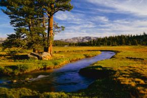
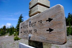
Climbing Mount Everest is a feat so enormous, so dangerous, so daunting, that few people consider it, much less actually do it. Yet more people have scaled Mount Everest, the world's tallest mountain, than thru-hiked America's Pacific Crest Trail [source: Pacific Crest Trail]. How can that possibly be? Because the Pacific Crest Trail (PCT), quite simply, is a beast. The trail stretches 2,650 miles (4,265 kilometers) from Mexico to Canada along the crests of the Sierra and Cascade mountain ranges, passing through six of North America's seven ecozones en route. As it zigs and zags through California, Oregon and Washington, it climbs nearly 60 major mountain passes, traverses three national monuments and seven national parks and crosses the San Andreas Fault three times [sources: Pacific Crest Trail, Pacific Crest Trail]. Hikers can be parched in desert terrain one day, then using ice axes to stop a treacherous fall the next. Thru-hiking the PCT -- hiking it in one season -- generally takes five to six months [source: Pacific Crest Trail]. Climbing Everest? Just several weeks [source: Alpine Ascents].

The PCT route was first explored in the 1930s, with trail pioneers Clinton Clarke and Warren Rogers subsequently petitioning the federal government to establish one continuous trail. Unfortunately, all that resulted were several unconnected paths in each state. After Congress authorized the National Trails System in 1968, the Pacific Crest and Appalachian Trails were designated the first two scenic trails in the system, and in 1993 the Pacific Crest Trail was formally dedicated [source: Pacific Crest Trail]. Although the PCT is considered completed, a few of its sections still run along the road. The plan is to secure a trail corridor for those sections so that eventually the PCT is totally off-road [source: USDA Forest Service].

Advertisement

The PCT is strictly for hikers or equestrians (no bicycles or mechanized vehicles are allowed), and you can traverse the trail for an hour or two, or several days, weeks or months. Access is easy from major cities such as San Diego, Los Angeles, San Francisco, Sacramento, Portland and Seattle [source: Pacific Crest Trail]. Each year about 300 people attempt to thru-hike the trail, with about 60 percent of those succeeding. A smaller number try to thru-ride the PCT on horseback, but only a handful of people have ever succeeded. Thru-hikers and riders normally move from south to north, starting in May and ending around September. This is easiest because of issues with heat, snow and rain [source: Pacific Crest Trail].

The PCT is divided into five sections based on location and terrain: Southern California, Central California, Northern California, Oregon and Washington.

Advertisement

Pacific Crest Hiking Guide: Southern California

Think heat, sun and thirst, and you've got a good idea of what the PCT's initial 648-mile (1,043-kilometer) section is generally like. The trail begins in a hot, dusty spot near Campo, a small town on the Mexican border at an elevation of 2,600 feet (793 meters). It winds through chaparral, scrub oaks and pines while temps soar to 90 and even 100 or more degrees Fahrenheit (32.2 to 37.7 degrees Celsius). There's little shade. Water sources are often 20 miles (32 kilometers) or more apart [source: Pacific Crest Trail].

The highest point in this section of the PCT comes in the San Jacinto Mountains, where the path rises to 9,030 feet (2,752 meters) and winds around granite peaks, subalpine forests and mountain meadows; it then plunges to its lowest spot (1,190 feet/363 meters) in San Gorgonio Pass. The trail continues across the San Andreas Fault Zone and western Mojave Desert, then enters the Sierra Nevada and the Central California section [source: Pacific Crest Trail].

Advertisement

The main challenge in Southern California is the extreme heat and lack of water. Even if you're only hiking a day, you need to make sure you're carrying plenty of water, plus know where you can obtain more. You should also know how to purify water, although on this stretch it can be difficult to find streams in some sections [source: Pacific Crest Trail].

Water isn't the only challenge here, though. The Southern California portion of the PCT is home to rattlesnakes, poison oak and flies, plus the innocuous-sounding Poodle Dog bush, a pretty, purple-flowered plant that can cause anything from a mild rash to severe respiratory distress if you touch it, or even if you touch clothing that has come into contact with the plant. It's best to wear long sleeves while traveling through the area [sources: Pacific Crest Trail, Pacific Crest Trail].

Advertisement

Pacific Crest Hiking Guide: Central California

Tuolumne Meadows
Early spring snow melt fills Budd Creek that flows through the grassy fields of Tuolumne Meadows.
Ron and Patty Thomas/Photographer's Choice/Getty Images

The Central California section (505 miles/813 kilometers) is known for its beauty and remoteness. The path traverses the stunning Sierra Nevada, which contains the lower 48 states' highest mountain, deepest canyon and longest wilderness. No kidding. If you walk this entire section, you'll climb 13,180 feet (4,017 meters) all the way up to Forester Pass, the trail's highest point, and in one area you'll be walking 200 miles (321 kilometers) in the wilderness before the path crosses a road [source: Pacific Crest Trail].

But the scenery is worth it. You'll be hiking through expansive meadows and conifer forests, then dip into deep canyons and rise up high saddles, all while surrounded by picturesque flora such as corn lilies, snow plants, red fir, Jeffrey and ponderosa pine, mule ears, mountain hemlock and white bark pines. You may spot critters like the marmot, coyote, deer, black bear, junco, Steller's jay and mountain chickadee [source: USDA Forest Service].

Advertisement

One of the most popular spots in the Central California section is where Sequoia National Park's popular John Muir Trail winds down from Mount Whitney to hook into the PCT; the trails then run together to Yosemite National Park's lush Tuolumne Meadows [source: Pacific Crest Trail]. And hikers love the numerous tiny lakes that dot this section of the trail, even above the tree line, thanks to the glaciers of long ago that left shallow basins when they receded, which eventually filled with water [source: USDA Forest Service].

With the arid desert clime behind you, the main challenges here come in the form of streams that are easily swollen by melting snows tumbling down from mountaintops and potentially icy high-mountain passes. Hikers here are advised to carry an ice axe and know how to self-arrest, which is a tricky, but highly effective, maneuver you use to stop yourself if you're sliding down an icy or snowy slope [source: Pacific Crest Trail].

Advertisement

Pacific Crest Hiking Guide: Northern California

Good-bye glaciated mountain terrain and into the volcanic Cascade mountain range. The lakes disappear, and hiking can get hot and dusty in late summer as the PCT now winds among old volcanic flows and ancient bedrock. But the nutrient-rich volcanic soils, coupled with the area's plentiful rains, mean you'll be strolling through lush forests and past picturesque plants like lupine, paintbrush, larkspur and gooseberry. You may not see the wildlife, but this area is home to creatures like the raccoon, marten, mink, badger, fox, bobcat, deer and black bear. In the fall, you may spot a wealth of birds migrating south along the Pacific Coast Flyway [source: Pacific Crest Trail].

This section is also prime logging country. The trail crosses over numerous back roads, unlike the previous section where roads are scarce. Even better, it meanders through Lassen Volcanic National Park, which sits in the shadow of Lassen Peak (10,457 feet/3,187 meters). Continuing on, you can see impressive Mount Shasta in the distance for quite some time [source: USDA Forest Service].

Advertisement

Thru-hikers are advised to hike this section in July and August. And they all know that when they're near Chester, just south of Lassen Volcanic National Park, they've reached the PCT's halfway point [source: Summit Post]. Even better, though, is the knowledge that when they've completed this section, they'll be out of California and in a new state.

Pacific Crest Hiking Guide: Oregon

pines
Towering pines near Mount Hood
George Diebold/Digital Vision/Getty Images

If the previous descriptions of the Pacific Crest Trail scared you off with their ruggedness, this might be the section for you. Oregon's 430 miles (692 kilometers) are the easiest on the entire PCT, with gentle climbs and well-graded paths that run through cool, shady woods. Thru-hikers often are able to put in their first 30- and even 40-mile (48- to 64-kilometer) days here [source: Pacific Coast Trail].

The landscape is still volcanic; you'll see volcanoes along the skyline such as Mount Hood, Mount Jefferson, the Three Sisters and Diamond Peak. But it's not stark. Near Mount Hood, for example, you can spot pinedrops and prince's pine in the dense forests filled with Douglas, silver and noble fir, then pasque flowers and fireweed growing in the frequent open areas. Throughout the trail, squirrels, beaver, fox, deer, elk, nutcrackers and grouse can be seen and heard, and there's an abundance of berries to sustain you: blackberries, huckleberries and salmonberries, to name a few [source: USDA Forest Service, Hanson].

Advertisement

One of Oregon's highlights is Mount Hood, the state's largest, most active volcano. Many summer hikers are surprised when the PCT runs under a ski lift near the Mount Hood Lodge -- and there are skiers and snowboarders on the slopes [source: Hanson]! Another popular spot for hikers is the passage through Crater Lake National Park, home to Crater Lake, the deepest lake in the U.S. and seventh deepest in the world. Take the Hiker PCT spur trail if you want to go right to the rim of this stunning lake [source: USDA Forest Service].

Before you leave the state, take a detour off the PCT onto the popular Eagle Creek Trail, which passes deep pools and cascades as it runs along a narrow gorge, then leads you through a tunnel carved behind a waterfall. Nearby is this section's only major elevation change -- when the trail plunges 3,160 feet (963 meters) into the Columbia River Scenic Gorge to cross the Columbia River via the Bridge of the Gods and leave Oregon behind [source: Hanson].

Advertisement

Pacific Crest Hiking Guide: Washington

This final stretch of the PCT is 500 miles (805 kilometers) and begins in the bottom of the Columbia River Scenic Gorge. Not surprisingly, it then climbs quite a while until reaching the base of Mount Adams (elevation 12,276 feet/3,742 meters). The Washington section of the PCT features the Northern Cascades, which offer up dramatic, mountainous scenery akin to the Sierra Nevada, including Mount Rainier, which you'll be able to see for many days. Rainier is the most glaciated peak in the lower 48, and an active volcano to boot. Look for plants and trees like western larch, Alaska cedar and grand fir, plus loads of huckleberry bushes. Don't be surprised to spot wildlife typical of more northern climes, such as mountain goats, grizzly bears and Canadian lynx [sources: USDA Forest Service, USDA Forest Service].

This is also the section with the most varied weather, as the North Cascades Range lies in a storm track most of the year. Count on it being green and pretty wet overall. But all of this moisture results in a soggy-but-beautiful hike, including a trek through Glacier Peak Wilderness, which features numerous switchbacks and rolling hills -- challenging, but beautiful -- plus 750 snowfields (areas perennially covered with snow) and small glaciers, thanks to that storm track. Altogether, the snowfields and glaciers contain about half the snowfield area in the lower 48 states [source: USDA Forest Service].

Advertisement

The PCT officially ends in the middle of the wilderness at the Canadian border. To make it easier to get back to civilization, the Canadian government created another 7 miles (11.2 kilometers) of trail that connect the PCT with Highway 3 in British Columbia's Manning Provincial Park [source: USDA Forest Service].

Most thru-hikers plan to finish this stretch in September, and all hikers are steered to this section in August and September, when the weather is best. But be prepared; even in September, it can get quite cold and snowy [source: Hanson].

Advertisement

Pacific Crest Hiking Guide: Food, Water and Re-Supplying

camping
Camping in the Mojave Desert
Ken Chernus/Taxi/Getty Images

Whether you plan to hike for a few hours or many days, you have to think about food and water when you'll be on the Pacific Crest Trail, and re-supplying if you'll be doing a long-distance hike. Day hikers can easily carry snacks on them for sustenance, and even those heading out for several days can easily carry all of their food on them. But if you plan to be hiking a few weeks or months, or thru-hiking, you'll need a food strategy.

Traditionally, long-distance hikers have mailed boxes of food to themselves to post offices in select towns along the route before they even start the trail. Then, when they reach each town, they replenish their food supplies. Others send just one box to the first town. When they arrive, they take the contents for their next stretch, then purchase more food in that town, refill the box and mail it to the next stop. Both of these methods work reasonably well, but they still pose several problems. Mailing food is expensive, for one. And what if you've packed numerous boxes of a certain kind of food that you end up hating partway through your hike, or that doesn't work well with your system? Or, what if you reach a town ahead of schedule and your box hasn't arrived yet, or you decide to skip a section? Increasingly, hikers are ditching the boxes and instead buying food in the towns along the way instead, or using some combination of both methods [source: Pacific Crest Trail]. But check out the stores ahead of time -- not every stop has "backpacking" food that's lightweight, full of calories and nutrients and that won't spoil in your pack. The following towns along the trail have full grocery stores, rather than just gas stations, where you can resupply: El Cajon, Idyllwild, Big Bear, Aqua Dulce, Tehachapi, Kennedy Meadows, Mammoth Lakes, South Lake Tahoe, Sierra City, Chester, Burney, Mount Shasta, Etna, Ashland and White Pass.

Advertisement

And then there's water. Water is always an issue on the PCT, whether you're hiking a day or more. There are long stretches without any water available -- the longest is 35.5 miles (57 kilometers) north of Tehachapi in the northern part of Southern California -- and you have to be prepared for emergencies as well [source: Pacific Crest Trail]. Grab a guidebook that lists all known water sources so you know how much to carry (most have this information). But in general, water is scarce in Southern California, and alternates between being plentiful and scarce in Northern California and Oregon [source: Pacific Crest Trail].

Even where water is plentiful -- Central California, Washington and parts of Northern California and Oregon -- boiling, treating or filtering it before drinking is essential, as many water sources are contaminated by pesticides, herbicides, fertilizers and organic parasites like Giardia lamblia and Cryptosporidium. If you plan to use a water filter or purifier, make sure it's effective against Giardia and bacteria. It helps if your device is also effective against Cryptosporidiosis and viruses. The most popular chemical water treatment is iodine, normally dissolvable tablets. Newer products made with stabilized chlorine dioxide are also gaining traction [source: Pacific Crest Trail].

Advertisement

Pacific Crest Hiking Guide: Trail Maps and Permits

You definitely need a map for the Pacific Crest Trail, as it's not blazed like its sister, the Google Earth and other mapping programs. It's good to carry a compass, too (and know how to use it) [sources: Hanson, Pacific Coast Trail].

Depending on where you'll be hiking along the trail, various permits are needed. For example, permits are required for all wilderness areas, national parks and other restricted areas along the trail. You can snag these permits at your point of origination. If you'll be hiking 500 miles (804.6 kilometers) or more, you can get a long-distance permit from the PCTA. Good for overnight use along the trail, the free permits cover the entire trip. There are also fire permits, Mount Whitney Zone permits and permits to enter Canada that may pertain to your trip [source: Pacific Coast Trail].

Advertisement

Pacific Crest Hiking Guide: Health and First Aid

hiking boots
Taking care of your feet is very important on a backpacking trip.
Daniel H. Bailey/Photolibrary/Getty Images

Whether you're hiking for a few hours or months, you should know the basics of first aid before you tackle the Pacific Crest Trail. Courses are often available through your American Red Cross branch or other local groups such as a recreational department. It's also wise to carry some medical supplies with you, such as adhesive strips, antibacterial ointment, sterile gauze pads and antihistamine tablets [source: Pacific Crest Trail].

The most common injuries among hikers, including those on the PCT, are bumps, bruises and foot ailments such as athlete's foot, blisters and cracked calluses. Since your feet are probably your most important asset as a hiker, here's what you should know about their preventive care and first aid [source: Pacific Crest Trail].

Advertisement

  • Whenever possible, take off your shoes and socks and air out your feet. If your socks are sweaty, change them.
  • Dunk your feet in a cool stream when it's hot out.
  • Elevate your legs to promote good circulation and reduce swelling.
  • At the end of every day, massage your feet and take care of any "hot spots" by covering them with bandages or moleskin.
  • If you develop athlete's foot, make sure to keep your feet as dry as possible and apply antifungal medication.
  • For filled blisters, drain with a sterilized needle and cover with a bandage. At night, remove the bandage to air out the area.
  • Some recommend superglueing together a cracked callus, which prevents the crack from deepening and reduces the pain. That may work, but you'll still need to moisturize the area.

Pacific Crest Hiking Guide: Bears

There's no getting around it -- the Pacific Crest Trail runs straight through black bear and grizzly bear habitat. And some sections of the pathway have seen a lot of bear activity. While unprovoked attacks are rare, the bears will try to get at your food. And they're pretty clever and agile. Don't tempt fate; in the Sierra Nevadas, for example, whenever there have been bear injuries, the injuries have always been associated with improper food storage [source: National Park Service].

Bear canisters are the most effective way to keep bears from food, and are required in some areas. In some parts of the trail where there's a lot of bear activity, the National Park Service has installed food storage lockers for your use -- large, metal containers where you can stash your goodies. Bear boxes -- basically the same thing as food storage lockers -- have also been installed along a 50-mile (80-kilometer) section of the PCT in the Sierra Nevadas. But it's probably best to carry a canister. Before you purchase one, however, make sure it's on the list of canisters approved by the National Park Service [source: Pacific Crest Trail]. And remember that the 2.5-pound, 11.8 liter canister will take up weight and space in your pack -- so plan accordingly!

Advertisement

Author's Note

Long-distance trails have fascinated me ever since I walked the 621-mile (1,000-kilometer) Vía de la Plata Camino trail in Spain a few years ago. Now I'm trying to learn as much as I can about some of America's biggies, such as the Appalachian Trail and, yes, the Pacific Crest, so this was the perfect assignment for me.

Related Articles

Sources

  • Alpine Ascents. "Everest." (May 17, 2012) http://www.alpineascents.com/everest-dtd.asp
  • GORP. "Pacific Crest Trail Overview." (May 14, 2012) http://www.gorp.com/parks-guide/travel-ta-national-scenic-trails-pacific-crest-trail-sidwcmdev_068997.html
  • Hanson, Vic. "Pacific Crest Trail." Summit Post. March 18, 2012. (May 17, 2012) http://www.summitpost.org/pacific-crest-trail/292576
  • National Park Service. "The Iconic Hikes: Mount Whitney, JMT & PCT." (May 17, 2012) http://www.nps.gov/seki/planyourvisit/upload/WTP-pages-12-21.pdf
  • Pacific Crest Trail. "Bears." (May 14, 2012) http://www.pcta.org//planning/before_trip/health/bears.asp
  • Pacific Crest Trail. "Central California." (May 14, 2012) https://www.pcta.org/about_trail/overview/central.asp
  • Pacific Crest Trail. "FAQs." (May 14, 2012) http://www.pcta.org/about_trail/faqs.asp
  • Pacific Crest Trail. "FAQs." (May 14, 2012) http://www.pcta.org//planning/before_trip/faqs.asp
  • Pacific Crest Trail. "First Aid." (May 14, 2012) http://www.pcta.org//planning/before_trip/health/firstaid.asp
  • Pacific Crest Trail. "Foot Care." (May 14, 2012) http://www.pcta.org//planning/before_trip/health/foot.asp
  • Pacific Crest Trail. "Fun Facts." (May 14, 2012) http://www.pcta.org/about_trail/fun.asp
  • Pacific Crest Trail. "Historical Perspective." (May 14, 2012) http://www.pcta.org/about_trail/threats.asp
  • Pacific Crest Trail. "Northern California." (May 14, 2012) http://www.pcta.org//about_trail/overview/northern.asp
  • Pacific Crest Trail. "Oregon." (May 14, 2012) http://www.pcta.org//about_trail/overview/oregon.asp
  • Pacific Crest Trail. "Pacific Crest National Scenic Trail Permits." (May 14, 2012) http://www.pcta.org//planning/before_trip/permits.asp
  • Pacific Crest Trail. "Re-Supply Strategy." (May 14, 2012) http://www.pcta.org//planning/before_trip/strategy.asp
  • Pacific Crest Trail. "Southern California." (May 14, 2012) https://www.pcta.org/about_trail/overview/southern.asp
  • Pacific Crest Trail. "Trail History." (May 14, 2012) http://www.pcta.org/about_trail/history.asp
  • Pacific Crest Trail. "Trail Overview." (May 14, 2012) https://www.pcta.org/about_trail/overview.asp
  • Pacific Crest Trail. "Trail Overview." (May 14, 2012) http://www.pcta.org//about_trail/overview/washington.asp
  • Pacific Crest Trail. "Turricula, the vicious Poodle-Dog bush." (May 14, 2012) http://www.pcta.org//planning/before_trip/health/turricula.asp
  • Pacific Crest Trail. "Water Sources and Purification." (May 14, 2012) http://www.pcta.org//planning/before_trip/health/water.asp
  • Schmidt, Steve. "Hikers Set Off To Take On Trial Of Pacific Trail." U-T San Diego. May 14, 2012. (May 14, 2012) http://www.utsandiego.com/news/2012/may/14/tp-hikers-set-off-to-take-on-trial-of-pacific/
  • Trails.com. "Pacific Crest National Scenic Trail Hiking Maps." (May 15, 2012) http://www.trails.com/pacific-crest-trail.aspx
  • USDA Forest Service. "California." (May 14, 2012) http://www.fs.usda.gov/detail/pct/home/?cid=stelprdb5304733
  • USDA Forest Service. "Frequently Asked Questions." (May 14, 2012) http://www.fs.usda.gov/detail/pct/home/?cid=stelprdb5310782
  • USDA Forest Service. "Oregon." (May 14, 2012) http://www.fs.usda.gov/detail/pct/home/?cid=stelprdb5304735
  • USDA Forest Service. "Pacific Crest National Scenic Trail." (May 14, 2012) http://www.fs.usda.gov/pct
  • USDA Forest Service. "Pacific Crest Trail." (May 15, 2012) http://www.fs.usda.gov/Internet/FSE_DOCUMENTS/stelprdb5330516.pdf
  • USDA Forest Service. "Washington." (May 14, 2012) http://www.fs.usda.gov/detail/pct/home/?cid=stelprdb5304737

Advertisement

Loading...