A Guide to Hiking the Ozarks

By: Becky Striepe  | 
Beautiful nature's outdoor water landscape.
One of the many scenic river landscapes in the Ozarks. See pictures of national parks.
Jupiterimages/Comstock/Thinkstock

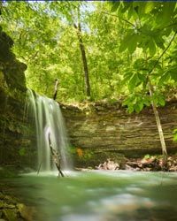
The U.S. is blessed with incredibly scenic areas full of hills, valleys, rivers, waterfalls, and trails. And the Ozarks are no exception. But what makes this mountain range so special are the waterways. You can hike along rivers and up or around waterfalls on your way through the woods. And while much of the Ozarks aren't technically wilderness, hikers say you can walk for miles without seeing another soul.

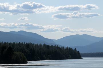
The Ozarks cover a huge area (about 60,000 square miles or 155,000 square kilometers) across Missouri, Arkansas, Oklahoma, and Kansas [source: U.S. Geological Survey]. While the Ozark Plateau hits these four states, the largest and most popular areas to hike are the Ozark Trail and the Ozark National Scenic Riverways in Missouri and the Ozark Highland Trail in Arkansas.

Advertisement

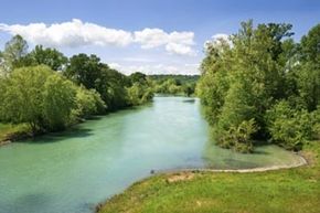
The Ozark National Scenic Riverways is part of the national parks system, and was the first national park created just to protect riverways [source: Poe]. Hikers can trek along the Current and the Jacks Fork River, rent a canoe and do some paddling, and even take a dip in the rivers to cool off [source: National Park Service].

The Ozark Trail is not a national park, but it does include 360 miles (579 kilometers) of gorgeous trails that run through national parks. The best of these is along the Current River, which is part of the Ozark National Scenic Riverways. People sometimes confuse the Ozark Trail with the Ozark National Scenic Riverways, but they're actually two different sets of trails, aside from that stretch along Current River.

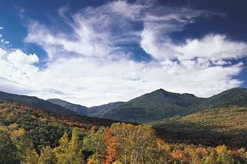
In Arkansas, the Ozark Trail meets up with the Ozark Highland Trail, which is considered to have some of the best vistas in the area. The 218-mile (350-kilometer) trail winds through mountains, waterfalls, and riverways [source: Ozark Highlands Trail Association]. There are even swimming holes where you can cool off during a hot summer hike. The trail goes right through the Ozark National Forest, where the trail was first established in the 1970s. When budget cuts to the U.S. Forest Service in the '80s stalled the project, Arkansas resident Tim Ernst helped start the Ozark Highlands Trail Association -- a volunteer organization -- to help maintain and expand the trail [source: White]. The trail has shorter loops for day hikers, and through hikers can trek the length of the unbroken trail and camp along the way.

Whether you choose to hike the Ozarks in Missouri or in Arkansas, you're in for stunning scenery. We'll give more details on the next page.

Advertisement

Hiking the Ozarks: Camping

Both the Missouri Ozarks and the Ozark Highland Trail have some great camping opportunities. They both allow camping along the trail and have some official campsites, if you prefer.

Because the Ozarks covers such a large area, it's a good idea to look into the climate where you're going to be camping and plan accordingly. Depending on where and when you go, you may need to prepare for cold weather, walking and camping near riverways, or making your way through wilderness. Elevation in the Ozarks varies quite a bit from mountains to valleys. That means that no matter what time of year, you should prepare for changes in temperature.

Advertisement

On the Missouri Ozark Trail, the rules about camping vary by section. The Ozark Trail Association maintains a page with trail conditions, and you can also click on each section to get more information about that leg of the trail, including camping rules and where to find campsites. For example, the Taum Sauk section has a couple of campgrounds, but if you're planning to camp elsewhere, you must make camp 100 feet (30.5 meters) from the trail [source: Ozark Trail Association]. The Ozark National Scenic Riverways have quite a few campsites, and you can find campsite infomation through the National Park Service.

The Ozark Highland Trail is very camping-friendly. You can pretty much camp wherever you want along the trail, and there are 18 public campgrounds along the trail, if you prefer less primitive camping conditions [source: Ozark Highlands Trail Association]. If pitching a tent isn't your thing, you might want to plan your trip around White Mountain Rock, where you can stay in a cabin instead.

Advertisement

Hiking The Ozarks: Mountain Rivers

Isn't it a joy to hike along a stream or a river, especially in the heat of summer? If you start to get overheated, you can just peel off your shoes and socks to cool down, and there's nothing like a splash of mountain water on your face to perk you up during a long hike.

In the Ozarks, you'll have plenty of opportunity for that. You can hike the Ozark Trail for a couple of miles along Current River or rent a canoe and float down the river or its sister river, the Jacks Fork [source: Missouri State Parks]. Abi Jackson at the Ozark Trail Association says that the stretch near the Current River where you're hiking up on the bluffs above the river is her favorite part of the trail.

Advertisement

In Arkansas, you can hike the Ozarks along the historic Buffalo National River. Buffalo River was an Arkansas state park from the late 30's until 1972, when it became the first river protected by the National Park Service [source: Arkansas Dept. of Parks and Recreation]. The national river is 135 miles (216 kilometers) long, and hikers can trek or float the length of the waterway. Because it's been protected for so long, the Buffalo River has a true wilderness feel.

If you're planning to hike along the river, you can really get the best of both worlds by mixing things up a bit! Instead of hiking a loop or trekking up and back, look for a local outfitter along the river where you're planning to hike. You can often park at the trailhead, take a shuttle to an outfitter, then canoe or float up the river and hike back.

Of course, where there are rivers, you can often find waterfalls. We'll look for some on the next page.

Advertisement

Hiking The Ozarks: Waterfalls

Amber Falls
Amber Falls in the Ozark National Forest.
iStockphoto/Thinkstock

Hiking up to a waterfall is one of my favorite things to do. I love the moment when you start to hear the rush of water and you know that a beautiful vista could be just around the next bend!

This may sound like a no-brainer, but if you're planning to hike to a waterfall, you need to be ready to get wet. Depending on the length of the walk back, you might want to pack a spare pair of socks in case you get drenched. Hiking in wet socks is the pits. If you're hiking in chillier weather, pack a rain jacket with a hood to protect yourself from the spray.

Advertisement

The Ozark Trail is home to a few notable waterfalls. Abi Jackson recommends a neat place along the Current River called Klepzig Mill with swimming holes and falls. She also suggests checking out Rocky Falls for its beautiful waterfall and swimming holes. Rocky Falls is about 40 feet (12.2 meters) high, and what makes it really spectacular is the purpleish rock from an ancient volcano that graces Rocky Creek as it tumbles down the falls [source: Uhlenbrock]. You can also hike up to Mina Sauk Falls, Missouri's tallest waterfall. The view here is best after a good rainfall, when the falls are at their heaviest [source: Uhlenbrock].

For more amazing waterfalls, you can't go wrong with the Ozark mountains in Arkansas. Which one you visit really depends on how far you're looking to hike. If you want to get right to the view, check out High Bank Twin Falls just 1/4 mile from where you'd park your car. Haw Creek Falls and Triple Falls are also just a short hike from the trailhead. You can even see a couple of falls without hiking at all. Check out Natural Dam and Falling Water Falls right from your car or the adjacent picnic areas. If you're looking for a moderate to difficult hike, Eden Falls or Hemmed-In Hollow Falls are good options. Of course, the most breathtaking views are also the toughest to get to. The hike up to Richland Falls and Twin Falls isn't very long – less than 2.5 miles (4 kilometers) – but the trail isn't very well marked, and the terrain is rough [source: Arkansas Dept of Park and Recreation].

Advertisement

Author's Note

My sister, Amanda, called while I was researching this article, and when I told her about it she asked if I was planning a trip. She just might have the right idea! I've done most of my hiking here on the East Coast, so I got a kick out of researching some of the beautiful terrain and scenery out west. I especially loved learning about all of the waterfalls in the Ozarks.

Trekking up to a waterfall is one of my favorite hiking adventures. Back when I was in college, some friends and I hiked up to a waterfall, and it was one of the most beautiful hikes I've been on. It was a warm clear day, and got pleasantly soaked on the way up. We ended up sitting at the top enjoying the scenery for much longer than we should have. Learn from my mistake: If you're not planning to camp, you want to start walking back down the mountain well before it gets dark. Hiking a waterfall in daylight is beautiful. Hiking back down in the dark is pretty terrifying. Even with the somewhat scary walk back, those views and that rushing water are still some of my favorite hiking memories.

Advertisement

Related Articles

Sources

  • Arkansas Dept of Parks and Recreation. "Buffalo National River 40th Anniversary." (April 30, 2012) http://www.arkansas.com/outdoors/buffalo40/
  • Arkansas Dept of Parks and Recreation. "Waterfalls." (April 30, 2012) http://www.arkansas.com/outdoors/waterfalls/
  • Jackson, Abi. Office Coordinator at Ozark Trail Association. Personal Interview. April 30, 2012.
  • National Park Service. "Hiking the Ozarks." (May 11, 2012) http://www.nps.gov/ozar/planyourvisit/hiking-in-the-ozarks.htm
  • Operator. Ozark National Scenic Riverways. Personal interview. April 30, 2012.
  • Poe, Noel. "Ozark National Scenic Riverways: History and Topography." OPTV. (May 11, 2012) http://video.optv.org/video/1393000188/
  • Ozark Highlands Trail Association. "Home." (April 30, 2012) http://ozarkhighlandstrail.com/
  • Ozark Highlands Trail Association. "Trail Map." (April 30, 2012) http://ozarkhighlandstrail.com/trail-map/
  • Ozark Trail Association. "Current River." (April 30, 2012) http://www.ozarktrail.com/currentriver.php
  • Ozark Trail Association. "OT History." (April 30, 2012) http://www.ozarktrail.com/history.php
  • Section Hiker. "Why does cotton kill?" (April 30, 2012) http://sectionhiker.com/why-does-cotton-kill/
  • Uhlenbrock, Tom. "7 Wonders of the Ozarks." Missouri State Parks. (April 30, 2012) http://mostateparks.com/blog/state-parks-stories/57898/7-wonders-ozarks
  • USGS. "Ozark Plateau and Ouachita Mountains." U.S. Geological Survey. (April 30, 2012) http://biology.usgs.gov/cro/d-ozark.htm
  • White, Mel. "The Intimate Wild." National Geographic. October 2008. (April 30, 2012) http://ngm.nationalgeographic.com/2008/10/ozark-trail/white-text/1

Advertisement

Advertisement

Loading...